Smøla
| Smøla kommune | |||
|---|---|---|---|
| Municipality | |||
 |
|||
|
|||
 Smøla within Møre og Romsdal |
|||
| Coordinates: 63°24′7″N 8°1′45″E / 63.40194°N 8.02917°ECoordinates: 63°24′7″N 8°1′45″E / 63.40194°N 8.02917°E | |||
| Country | Norway | ||
| County | Møre og Romsdal | ||
| District | Nordmøre | ||
| Administrative centre | Hopen | ||
| Government | |||
| • Mayor (2011) | Roger Osen (AP) | ||
| Area | |||
| • Total | 281.82 km2 (108.81 sq mi) | ||
| • Land | 270.44 km2 (104.42 sq mi) | ||
| • Water | 11.38 km2 (4.39 sq mi) | ||
| Area rank | 285 in Norway | ||
| Population (2013) | |||
| • Total | 2,180 | ||
| • Rank | 321 in Norway | ||
| • Density | 8.1/km2 (21/sq mi) | ||
| • Change (10 years) | -3.8 % | ||
| Demonym(s) | Smølværing | ||
| Time zone | CET (UTC+1) | ||
| • Summer (DST) | CEST (UTC+2) | ||
| ISO 3166 code | NO-1573 | ||
| Official language form | Neutral | ||
| Website | www |
||
|
|
|||
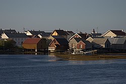
Smøla is a municipality in Møre og Romsdal county, Norway. It is part of the Nordmøre region. The administrative centre of the municipality is the village of Hopen, other villages include Dyrnes, Råket, and Veiholmen.
The municipality of Smøla was established on 1 January 1960 after the merger of the municipalities of Edøy, Brattvær, and Hopen. The initial population was 4,046. The boundaries have not changed since that time.
The municipality is named after the main island of Smøla (Old Norse: Smyl or Smjöl). The name is probably related to Modern Norwegian smule and smuldre which means "crumble", referring to the thousands of small islands and islets around the main island. Researchers at the Technical University of Berlin have claimed that Smøla is the island which Pytheas called Thule (Greek: Θούλη, Thoúlē).
The coat-of-arms is from modern times; they were granted in 1989. The arms show two white seagulls on a red background. This design was chosen to highlight the fact that this is an island community.
The Church of Norway has three parishes within the municipality of Smøla. It is part of the Ytre Nordmøre deanery in the Diocese of Møre.
...
Wikipedia


