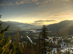
Slocan City
| Slocan | |
|---|---|
| Village | |
| Village of Slocan | |
 |
|
| Location of Slocan in British Columbia | |
| Coordinates: 49°45′58″N 117°28′6″W / 49.76611°N 117.46833°W | |
| Country |
|
| Province |
|
| Region | West Kootenay (Slocan Valley) |
| Regional district | Central Kootenay |
| Incorporated | 1901 |
| Government | |
| • Governing body | Slocan Village Council |
| • Mayor | Jessica Lunn |
| Area | |
| • Total | 0.78 km2 (0.30 sq mi) |
| Elevation | 450 m (1,480 ft) |
| Population (2011) | |
| • Total | 296 |
| • Density | 381.7/km2 (989/sq mi) |
| Time zone | PST (UTC-8) |
| Highways | 6 |
| Waterways | Slocan Lake, Slocan River |
The Village of Slocan (/sloʊˈkæn/ sloh-KAN), historically also known as Slocan City (/ˈsloʊkæn/ SLOH-kən), from Ktunaxa: sⱡuqan, IPA: [sɬuqan]). is a village in the Slocan Valley of the West Kootenay region of the southeastern Interior of British Columbia, Canada. It is located at the southern end of Slocan Lake, to the south of New Denver, which sits mid-way up the lake's eastern shore.
The name Slocan is derived from the Sinixt word meaning "to strike or pierce on head" and was derived from their practice of harpooning salmon. At one time, this area had an abundance of salmon. The term Slocan is also in the Ktunaxa language.
...
Wikipedia

