Sleeping Giant (Connecticut)
| Sleeping Giant | |
|---|---|

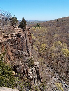
View from the Giant's Chin
|
|
| Highest point | |
| Elevation | 739 ft (225 m) |
| Coordinates | 41°25′50″N 72°53′27″W / 41.43056°N 72.89083°WCoordinates: 41°25′50″N 72°53′27″W / 41.43056°N 72.89083°W |
| Geography | |
|
|
|
| Parent range | Metacomet Ridge |
| Geology | |
| Age of rock | 200 Ma |
| Mountain type | Fault-block; igneous |
| Climbing | |
| Easiest route | casual uphill walk (via Tower Path) |
| Sleeping Giant State Park | |
| Connecticut State Park | |
| Country | |
|---|---|
| State | |
| County | New Haven |
| Town | Hamden |
| Elevation | 522 ft (159 m) |
| Area | 1,465 acres (593 ha) |
| Established | 1924 |
| Management | Connecticut Department of Energy and Environmental Protection |
| Website: Sleeping Giant State Park | |
|
Sleeping Giant Tower
|
|

Lookout tower at the summit of the Giant
|
|
| Location | Hamden, Connecticut |
| Coordinates | 41°25′50.29″N 72°53′26.76″W / 41.4306361°N 72.8907667°W |
| Built | 1936 |
| Architect | Works Progress Administration |
| Architectural style | Other, Romanesque |
| MPS | Connecticut State Park and Forest Depression-Era Federal Work Relief Programs Structures TR |
| NRHP Reference # | 86001754 |
| Added to NRHP | September 4, 1986 |
Sleeping Giant (also known as Mount Carmel) of south-central Connecticut, with a high point of 739 feet (225 m), is a rugged traprock mountain located 8 miles (13 km) north of New Haven. It is part of the narrow, linear Metacomet Ridge that extends from Long Island Sound near New Haven, north through the Connecticut River Valley of Massachusetts to the Vermont border. A prominent landscape feature visible for miles, the Sleeping Giant receives its name from its anthropomorphic resemblance to a slumbering human figure as seen from either the north or south. The Giant is known for its expansive clifftop vistas, rugged topography, and microclimate ecosystems. Most of the Giant is located within Sleeping Giant State Park. The mountain is a popular recreation resource; over 30 miles (48 km) of hiking trails traverse it including 5 miles (8 km) of the 23-mile (37 km) Quinnipiac Trail.Quinnipiac University is located at Mount Carmel's foot in Hamden.
The Sleeping Giant, 2.75 miles (4.43 km) long by 1.75 miles (2.82 km) wide, is located in Hamden with its eastern edge falling into Wallingford. The Giant's profile features distinct "head", "chin", "chest", "hip", "knee" and "feet" sections topographically represented by traprock outcrops and ridge crests. The highest point is the Left Hip, 739 ft (225 m), followed by the Chest, 710 ft (220 m), and the Left Knee and Right Leg, 700 ft (210 m) each, and so on. The Giant's Head, 670 ft (200 m), is marked by a 400 ft (120 m) cliff. A stone observation tower located on the Left Hip, built by the Works Progress Administration in the 1930s, offers 360° views of the surrounding Mill and Quinnipiac River valleys. An old rock quarry, closed since 1933 and now part of the state park, has left scars on the Giant's Head.
...
Wikipedia


