Slatington, Pennsylvania
| Borough of Slatington | |
| Borough | |
|
619/621/623/625 Main St., Slatington, Pennsylvania
|
|
| Nickname: The Slate Capital of America | |
| Country | United States |
|---|---|
| State | Pennsylvania |
| County | Lehigh |
| Elevation | 490 ft (149.4 m) |
| Coordinates | 40°45′09″N 75°36′33″W / 40.75250°N 75.60917°WCoordinates: 40°45′09″N 75°36′33″W / 40.75250°N 75.60917°W |
| Area | 1.4 sq mi (3.6 km2) |
| - land | 1.3 sq mi (3 km2) |
| - water | 0.1 sq mi (0 km2), 7.14% |
| Population | 4,232 (2010) |
| Settled | 1738 |
| - Established | 1864 |
| Timezone | EST (UTC-5) |
| - summer (DST) | EDT (UTC-4) |
| ZIP code | 18080 |
| Area code | 610 Exchanges: 760, 767 |
|
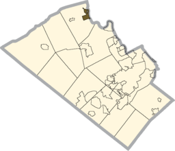
Location of Slatington in Lehigh County
|
|
|
Location of Pennsylvania in the United States
|
|
Slatington is a borough in Lehigh County, Pennsylvania. It is located 20 miles north of Bethlehem, in the Lehigh Valley region of the state. It is 62 miles south of Scranton, and 98 miles west of New York City.
Slatington is included in the Allentown-Bethlehem-Easton, PA-NJ Metropolitan Statistical Area, which is also included in the New York City-Newark, New Jersey, NY-NJ-CT-PA Combined Statistical Area.
Slatington is located at 40°45′9″N 75°36′33″W / 40.75250°N 75.60917°W (40.752561, -75.609229).
According to the United States Census Bureau, the borough has a total area of 1.4 square miles (3.6 km2), of which 1.3 square miles (3.4 km2) is land and 0.1 square miles (0.26 km2) (4.35%) is water.
Slatington's elevation is 738 feet above sea level. Slatington's elevation varies from 330 feet at the Lehigh River on the east side of town to 750 feet by the Union Cemetery on Route 873 to the south.
...
Wikipedia


