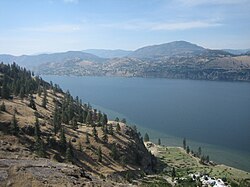
Skaha Lake
| Skaha Lake | |
|---|---|
 |
|
| Location | British Columbia |
| Coordinates | 49°25′N 119°35′W / 49.417°N 119.583°WCoordinates: 49°25′N 119°35′W / 49.417°N 119.583°W |
| Primary inflows | Okanagan River |
| Primary outflows | Okanagan River |
| Catchment area | Okanagan Basin |
| Basin countries | Canada |
| Max. length | 11.8 kilometres (7.3 mi) |
| Max. width | 2.2 kilometres (1.4 mi) |
| Surface area | 19.6 square kilometres (7.6 sq mi) |
| Average depth | 26.6 metres (87 ft) |
| Max. depth | 56.7 metres (186 ft) |
| Water volume | 0.552 cubic kilometres (0.132 cu mi) |
| Residence time | 1.1 years |
| Shore length1 | 30.7 kilometres (19.1 mi) |
| Surface elevation | 339 m (1112 ft) |
| Frozen | February 2014 |
| Settlements | Penticton, Okanagan Falls |
| 1 Shore length is not a well-defined measure. | |
Skaha Lake, historically known as Dog Lake and originally Lac Du Chien, is a freshwater lake located along the course of the Okanagan River in the Okanagan Valley of British Columbia, Canada. It has a surface area of approximately 20 km², with a maximum depth of 55 metres. The lake is situated directly south of Okanagan Lake and forms the southern shoreline and boundary of the city of Penticton, British Columbia. The community of Okanagan Falls is located at its southern end, the community of Kaleden lies in the upland area to its west.
"Labelled "L. du Chien" (Dog Lake) on Anderson Map, 1867; labelled "Du Chien L." on Trutch maps, 1866 and 1871. Origin unknown. Later, Dog became the official name. Changed in 1930 to Skaha "to agree with the local name," states the Chief Geographer. However Okanagan Indians say "skaha" is not their word for dog, but is that of the Shuswaps, and that the local word for dog is chokowapee. (Parham, 40). Another spelling is kaekuwapa. The local meaning of skaha is "horse". (Albert Millar). That is also the meaning in the Nicola dialect. (W. G. Clapperton)."
Lake Skaha from Christie Memorial Park
Skaha Lake along the Okanogan River
Northern end of Lake Skaha on a winter afternoon
...
Wikipedia
