Skagerak
| Skagerrak | |
|---|---|

Skagerrak and Kattegat
|
|
| Location | North Sea–Kattegat (Atlantic Ocean) |
| Coordinates | 57°50′50″N 9°04′23″E / 57.84722°N 9.07306°ECoordinates: 57°50′50″N 9°04′23″E / 57.84722°N 9.07306°E |
| Type | Strait |
| Basin countries |
Norway Denmark Sweden |
| Surface area | 47,000 km2 (18,000 sq mi) |
| Average depth | 200 metres (660 ft) |
| Max. depth | 700 metres (2,300 ft) |
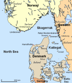
The Skagerrak (Danish: [ˈsɡæjɐʁaɡ]; Norwegian: [ˈskɑːɡərɑk]; Swedish: [ˈskɑːɡərak]) is a strait running between the southeast coast of Norway, the southwest coast of Sweden, and the Jutland peninsula of Denmark, connecting the North Sea and the Kattegat sea area, which leads to the Baltic Sea.
The Skagerrak contains some of the busiest shipping routes in the world, with vessels from every corner of the globe. It also supports an intensive fishing industry. The ecosystem is strained and negatively affected by direct human activities. Oslo is the only large city in the Skagerrak region.
The meaning of Skagerrak is most likely the Skagen Channel/Straight. Skagen is a town near the northern cape of Denmark (The Skaw). Rak means 'straight waterway' (compare the Damrak in Amsterdam); it is cognate with 'reach'. The ultimate source of this syllable is the Proto-Indo-European root *reg-, 'straight'. Rak means 'straight' as in 'straight ahead' in both modern Norwegian and Swedish. "Råk" in modern Norwegian refers to a channel or opening of water in an otherwise ice covered body of water. There is no evidence to suggest a connection with the modern Danish word rak (meaning rabble or riff-raff). [See Kattegat for its etymology, in which gat means gate or hole.]
...
Wikipedia
