Six Mile, South Carolina
| Six Mile, South Carolina | |
|---|---|
| Town | |

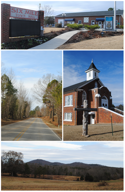
Top, left to right: Six Mile Town Hall, Liberty Highway, Six Mile Baptist Church, view of nearby mountain from Main Street
|
|
 Location of Six Mile, South Carolina |
|
| Coordinates: 34°48′7″N 82°49′4″W / 34.80194°N 82.81778°WCoordinates: 34°48′7″N 82°49′4″W / 34.80194°N 82.81778°W | |
| Country | United States |
| State | South Carolina |
| County | Pickens |
| Area | |
| • Total | 1.8 sq mi (4.7 km2) |
| • Land | 1.8 sq mi (4.7 km2) |
| • Water | 0.0 sq mi (0.0 km2) |
| Elevation | 1,024 ft (312 m) |
| Population (2000) | |
| • Total | 553 |
| • Density | 304.4/sq mi (117.5/km2) |
| Time zone | Eastern (EST) (UTC-5) |
| • Summer (DST) | EDT (UTC-4) |
| ZIP code | 29682 |
| Area code(s) | 864 |
| FIPS code | 45-66760 |
| GNIS feature ID | 1226654 |
| Website | www.sixmilesc.org |
Six Mile is a town in Pickens County, South Carolina, United States. The 2010 census showed a population of 675, representing a 21% increase since 2000.
Six Mile was named "Six Mile" because it was located six miles from Fort Prince George. Many other landmarks in this area were named by their distance from Fort Prince George such as 12 Mile River and 18 Mile Creek.
Six Mile is located at 34°48′7″N 82°49′4″W / 34.80194°N 82.81778°W (34.801983, −82.817857).
According to the United States Census Bureau, the town has a total area of 1.8 square miles (4.7 km²), of which 1.8 square miles (4.7 km²) is land and 0.55% is water.
The climate is mild and temperate with rainfall evenly distributed throughout the year. Winters are moderate with an average monthly temperature of 43. Snowfall occurs each winter, but significant amounts come only once every two or three years. Spring is a period of transition with March the month for heavy rains. As the showers decrease, a secondary dry period occurs late in April and early May. Steady rains typical of winter are likely in early spring. The average date of the last spring freeze falls around the end of March, which gives the area a growing season of approximately 180–200 days. Summers are warm and long with the average temperatures hovering around 79. Temperatures reach 90 on an average of 48 days a year. Six Mile’s warm and pleasant autumn is the driest season of the year with the first frost usually occurring the first week of November.
The area now known as Six Mile once belonged to the Cherokee Nation. A popular legend says that Six Mile was named by the Indian maiden, Issaqueena, who rode her horse on a journey of ninety-six miles to warn her lover, an English trader named Francis Allen, of a coming Cherokee attack on the fort where he was staying called Star Fort. Issaqueena numbered the creeks she crossed until she reached the fort in the area she labeled Ninety Six. There is a town called Ninety Six, and many other “number names” on the path to it; these include Mile Creek, Six Mile, Twelve Mile River, and Six and Twenty Creek. According to the legend, Issaqueena succeeded in warning Allen and they married and had a child, only later to be pursued by, and escape, the Cherokee. This tale is similar to many of Six Mile’s other legendary events in that it stresses courage, bravery, ingenuity, and determination.
...
Wikipedia
