Sivasagar
|
Sivasagar শিৱসাগৰ Sibsagar |
|
|---|---|
| Town | |

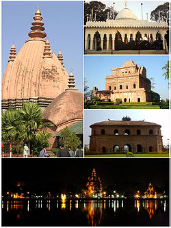
Clockwise from top: Sivadol, Ajanpir Dargah, Garhgaon's Kareng ghar, Rang ghar and night view of Sivasagar tank
|
|
| Location in Assam, India | |
| Coordinates: 26°59′N 94°38′E / 26.98°N 94.63°ECoordinates: 26°59′N 94°38′E / 26.98°N 94.63°E | |
| Country |
|
| State | Assam |
| District | Sivasagar |
| Government | |
| • Body | Sivasagar Municipality Board |
| Elevation | 95 m (312 ft) |
| Population (2011) | |
| • Total | 1,151,050 |
| Languages | |
| • Official | Assamese |
| Time zone | IST (UTC+5:30) |
| PIN | 785640 |
| Telephone code | 91-3772 |
| ISO 3166 code | IN-AS |
| Vehicle registration | AS 04 |
| Nearest city | Jorhat, Dibrugarh |
| Website |
www |
Sivasagar {Pron: ˈsɪvəˌsʌgə(r) or ˈʃɪvəˌsʌgə(r)} ( Xiwôxagôr) previously spelled Sibsagar ("the ocean of Lord Shiva"), is a town in Upper Assam, about 360 kilometres (224 mi) north east of Guwahati. It is the district headquarters of the Sivasagar district.
It is well known for its Ahom palaces and monuments. Sivasagar today is also an important centre for the tea and oil industries.
Sivasagar, formerly known as Rangpur, was the capital of the Ahom Kingdom from 1699 to 1788. The Ahoms ruled Assam for six centuries, until their kingdom fell to the Burmese in 1819 and their ruling class was all but wiped out.
The province was liberated by the British in 1825 but, owing to the state of anarchy which prevailed, it was completely annexed in 1826. For administrative purposes it was divided into three sub-divisions.
It is said that the original name of Sivasagar was - 'Kalansupar' after the name of 'Kalansu Gohain' who resided in a village originally existed in the place where currently the Sivasagar tank is located. [1][2]
This town's main feature is the water body from which it takes its name. This is a 257-acre (1.04 km2) tank, also known as the Borpukhuri, which is at a higher elevation than the rest of the town, with three temples ("Dol"s in Assamese) on its banks. Of these temples, the most prominent is the Sivadol, standing tall at 104 feet (32 m), drawing large crowds on Shiv Ratri. The other temples are the Vishnudol and Devidol. The temples were built by Kuwori Ambika, wife of Swargadeo Siba Singha, in 1734.
The Land
It was in the middle ages that king Rudra Singha (1690 AD - 1714 AD), the 30th Ahom ruler got the fourth capital town constructed at Meteka and christened it as Che-mon. The construction of the new capital ‘Chemon’ or Rangpur was started in 1699 AD and after completion it was inaugurated in 1707 A.D. However, the existing capital at Gargoan continued to function as the centre of administration whereas the new capital town at Rangpur was initially used as an army cantonment, centre of amusement, secretariat and court of law.
...
Wikipedia


