Sivaganga district
|
Sivaganga District சிவகங்கை மாவட்டம் Sivagangai Mavattam |
|
|---|---|
| District | |

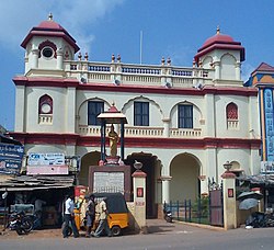
Entrance to the Velu Nachiar Palace, Sivaganga
|
|
 Location in Tamil Nadu, India |
|
| Coordinates: 9°43′0″N 78°49′0″E / 9.71667°N 78.81667°ECoordinates: 9°43′0″N 78°49′0″E / 9.71667°N 78.81667°E | |
| Country |
|
| State | Tamil Nadu |
| District | Sivaganga |
| Headquarters | Sivaganga |
| Talukas | Sivaganga, Karaikudi, Devakottai, Manamadurai, ilayangudi, Thirupathur, kalaiyarkovil,singampunari. |
| Government | |
| • Collector | S Malarvizhi, IAS |
| • Superintendent of Police | T Jayachandran, IPS |
| Area | |
| • Total | 4,189 km2 (1,617 sq mi) |
| Population (2011) | |
| • Total | 1,339,101 |
| • Density | 274.7/km2 (711/sq mi) |
| Languages | |
| • Official | Tamil |
| Time zone | IST (UTC+5:30) |
| PIN | 630561 |
| Telephone code | 04575 |
| ISO 3166 code | [[ISO 3166-2:IN|]] |
| Vehicle registration | TN-63 |
| Largest city | Karaikudi |
| Sex ratio | M-49%/F-51% ♂/♀ |
| Literacy | 52.5%% |
| Legislature type | elected |
| Climate | Very dry and hot with low humidity (Köppen) |
| Precipitation | 875.2 millimetres (34.46 in) |
| Website | www |
Sivaganga District is an administrative district of Tamil Nadu state in Southern India. It is bounded by Pudukkottai district on the Northeast, Tiruchirapalli district on the North, Ramanathapuram district on South East, Virudhunagar district on South West and Madurai District on the West.The major town in the district is the City of Karaikudi. As of 2011, the district had a population of 1,339,101 with a sex-ratio of 1,003 females for every 1,000 males.
Sivaganga District has been carved out from composite Ramnad District (G.O. MS. No. 1122 Rev. Dept. Dated. 6.7.84) and the District was functioning from 15.3.85 (G.O Ms.No. 346 Rev. dept. Dated: 8.3.85).
According to the 2011 census, Sivagangai district had a population of 1,339,101 with a sex-ratio of 1,003 females for every 1,000 males, much above the national average of 929. A total of 137,235 were under the age of six, constituting 70,022 males and 67,213 females. Scheduled Castes and Scheduled Tribes accounted for 17.01% and .06% of the population respectively. In addition, the average literacy of the district was 71.67%, compared to the national average of 72.99%, while the district had a total of 338,938 households. On the other hand, there is a total of 620,171 workers, comprising 117,030 cultivators, 122,166 main agricultural labourers, 9,864 in house hold industries, 212,042 other workers, 159,069 marginal workers, 23,973 marginal cultivators, 77,397 marginal agricultural labourers, 4,792 marginal workers in household industries and 52,907 other marginal workers.
Sivaganga district of Tamil Nadu spreads over 4,189 km2. The geographical position of Sivaganga district is between 9° 43' and 10° 2' north latitude and between 77° 47' and 78° 49' east longitude. It is bounded on the north and northeast by Pudukkottai District, on the southeast and south by Ramanathapuram District, on the southwest by Virudhunagar District, and on the west by Madurai District, and on the northwest by Tiruchirappalli District.
...
Wikipedia
