Sirsi, Karnataka
|
Sirsi ಶಿರಸಿ Kalyanapattana |
|
|---|---|
| City | |

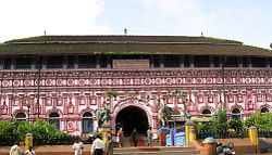
Marikamba temple at Sirsi
|
|
| Location in Karnataka, India | |
| Coordinates: 14°37′10″N 74°50′07″E / 14.6195°N 74.8354°ECoordinates: 14°37′10″N 74°50′07″E / 14.6195°N 74.8354°E | |
| Grid position | MK74 |
| Country |
|
| State |
|
| District | Uttara Kannada |
| region | Kanara |
| Government | |
| • Body | City Municipal Council |
| Area | |
| • Total | 11.2 km2 (4.3 sq mi) |
| Elevation | 610 m (2,000 ft) |
| Population (2011) | |
| • Total | 95,574(town) 178,784(UA) |
| Languages | |
| • Official | Kannada |
| Time zone | IST (UTC+5:30) |
| PIN | 581401, 581402, 581403 |
| Telephone code | +91-8384 |
| Vehicle registration | KA-31 |
| Literacy | 92.82% |
| Sex ratio | 1014 ♂/♀ |
| Website | www |
Sirsi is a city in the Uttara Kannada district in the Indian state of Karnataka. Sirsi was also known as Kalyanapattana during the Sonda Dynasty. It is a tourist destination with a population of 95,574. It is the largest city and main commercial centre and business hub in Uttara Kannada district. The city is surrounded by forest and the region is popular for a large number of waterfalls. Hubli and Shimoga are the nearest large cities. The main businesses around the city are mostly subsistence and agriculture based. Adike (Supari) (Areca nut) or (betel nut) is the primary crop grown in the villages that surround the city, making it one of the major trading centres for Arecanut. The nuts grown there are transported all over India, and also exported abroad. The region is also popular for many other spices like cardamom, pepper, betel leaves and vanilla. The major food crop is paddy and rice is the staple food of the people.
Sirsi is located at 14°37′N 74°51′E / 14.62°N 74.85°E (Grid Square MK74). It has an average elevation of 590 metres (1936 feet), and is situated in the heart of the Western Ghats. Sirsi is about 425 km from Bangalore. The nearest airport is located in Hubli, about 102 km from Sirsi. River Aghanashini begins at a place near Sirsi called "Donihalla" and flows towards the Arabian Sea in the West. The river also creates many waterfalls along its path. Yana (Kannada: ಯಾಣ) is a village located in forests of the Uttara Kannada district of Karnataka, India, which is known for the unusual rock formations (karst) or (asteroid). It is located in the Sahyadri mountain range of the Western Ghats, about 60 kilometres (37 mi) from Karwar port, 40 kilometres (25 mi) from Sirsi, and 31 kilometres (19 mi) from Kumta. The two unique rock outcrops near the village are a tourist attraction and easily approachable by a small trek through 0.5 kilometres (0.31 mi) of thick forests from the nearest road head.
...
Wikipedia

