Siroki Brijeg
|
Široki Brijeg Широки Бријег |
|||
|---|---|---|---|
| City | |||

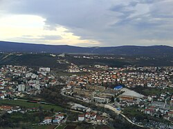
The City of Široki Brijeg panorama
|
|||
|
|||
 Location of Široki Brijeg in Bosnia and Herzegovina |
|||
| Location of Široki Brijeg in Bosnia and Herzegovina | |||
| Coordinates: 43°22′59.31″N 17°35′33.86″E / 43.3831417°N 17.5927389°ECoordinates: 43°22′59.31″N 17°35′33.86″E / 43.3831417°N 17.5927389°E | |||
| Country | Bosnia and Herzegovina | ||
| Entity | Federation of Bosnia and Herzegovina | ||
| Canton | West Herzegovina | ||
| Government | |||
| • Mayor | Miro Kraljević (HDZ BiH) | ||
| Area | |||
| • Total | 387.6 km2 (149.7 sq mi) | ||
| • Land | 387.6 km2 (149.7 sq mi) | ||
| • Water | 0 km2 (0 sq mi) | ||
| Elevation | 312 m (1,024 ft) | ||
| Population (2013) | |||
| • Total | 29,809 | ||
| • Density | 77/km2 (200/sq mi) | ||
| Time zone | CET (UTC+1) | ||
| • Summer (DST) | CEST (UTC+2) | ||
| Post code | 88220 | ||
| Area code | +387 039 | ||
| Website | www |
||
Široki Brijeg (![]() pronunciation ) is a city in Bosnia and Herzegovina. It is located in the West Herzegovina Canton, a unit of the Federation of Bosnia and Herzegovina. It is one of the twelve official cities of Bosnia and Herzegovina.
pronunciation ) is a city in Bosnia and Herzegovina. It is located in the West Herzegovina Canton, a unit of the Federation of Bosnia and Herzegovina. It is one of the twelve official cities of Bosnia and Herzegovina.
The name of the city means "wide hill". It is sometimes referred to as Široki Brig or simply Široki ("wide"). Between 1945 and 1990, the town was officially called Lištica, after the river that flows through it.
The river Lištica runs through Široki Brijeg. The town is 20–25 km (12–16 mi) from Mostar, 42 km (26 mi) from Međugorje, and 88 km (55 mi) from the Adriatic coast (Ploče).
The Široki Brijeg Municipality today numbers around 30,000 people, and the city itself about 13,000. The area of the municipality amounts to 1,168 ha (2,886 acres; 5 sq mi). The center of town is at 270 m (886 ft) above sea level, while its area is known as "lower Herzegovina". Almost the entire northern part of the municipality itself, however, belongs to "high Herzegovina", the highest point being the Bile stine ("White Rocks") near Donji Crnač.
Široki Brijeg has mild submediterranean-mountain climate. Winters are chilly and often very cold. Summers are warm.
The wider area of the municipality of Široki Brijeg is located on the characteristic, complex structural forms known as the "high karst zone" in geologic terms. The basic characteristic is the rocky limestone relief in various karst forms (sinks, caves, sinkholes, karst fields, etc.), as well as deeply cut valleys with occasional torrents flows. The Široki Brijeg area is located on the direction of tectonic units Rakitno-Hrgud and spreads over Rakitno, Vardi mountains, Mostarsko Blato, Rotimlje and Hrgud to Trebišnjica in the southeast. The area is made-up of up late Jurassic sediments, followed by Cretaceous and Paleogene age layers, then Neogene and Quaternary deposits. Highlights are early Cretaceous dun, well stratified limestone and dolomites. Late Cretaceous deposits, cenoman-turon, are represented by white and pink, massive limestone with the shoot. In Paleogenic layers function Liburnijska and alveolinic-nummulitic limestones, then eocenic flysch, which is represented by marl, sandstone, calcarenite and conglomerates.
...
Wikipedia


