Sinks Canyon State Park
| Sinks Canyon State Park | |
| Wyoming State Park | |
|
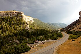
Sinks Canyon State Park, looking west from the entrance of the canyon
|
|
| Country | United States |
|---|---|
| State | Wyoming |
| County | Fremont |
| Nearest town | Lander |
| Elevation | 6,122 ft (1,866 m) |
| Coordinates | 42°43′22″N 108°52′30″W / 42.72278°N 108.87500°WCoordinates: 42°43′22″N 108°52′30″W / 42.72278°N 108.87500°W |
| Area | 600 acres (243 ha) |
| Established | 1971 |
| Management | Wyoming Division of State Parks and Historic Sites |
| IUCN category | V - Protected Landscape/Seascape |
| Website: Sinks Canyon State Park | |
Sinks Canyon State Park is a public recreation and nature preservation area located in the Wind River Mountains, 6 miles (9.7 km) southwest of Lander, Wyoming, on Wyoming Highway 131. The state park is named for a portion of the Middle Fork of the Popo Agie River where it flows into an underground limestone cavern, named "the Sinks," and emerges a quarter-mile down the canyon in a pool named "the Rise." The park is managed by the Wyoming Division of State Parks and Historic Sites.
Human activity in Sinks Canyon goes back thousands of years. Archaeological digs have found hearths and tools carbon dated as far back as the last ice age. Since the late 19th century, the canyon and its river have been utilized for a variety of purposes. A saw mill, small hydroelectric dam and power plant, and ski area have all operated in the canyon.
A hydroelectric dam and power plant were built in the canyon in the late 1910s by the Sinks Canyon Hydro Power Company and became operational by January 1920. The purpose of the plant was to supply nearby Lander with more reliable electricity. Power generation was possible most of the year except during winter months because water levels become too low. The design of the system consisted of a small stone-concrete dam standing 9 feet high and 60 feet wide built on the Popo Agie River a short distance upstream. The dam connected to the power house located at the Rise via a 3,145 foot long riveted-steel pipeline with a diameter of between 30 and 26 inches. The pipeline allowed water to flow at a rate of 17 feet per second until reaching the power house. The power house contained two 47 inch 250 horsepower hug impulse wheels, each spun by two 3 inch diameter water nozzles. The two wheels were controlled by two separate Lombard oil-pressure generators which were connected to a 150-kilowatt 3 phase 60 cycle alternating-current generator operating at 2,300 volts. The power was transmitted at 11,000 volts over a copper circuit suspended by cedar poles to Lander and South Pass City as well as some oil extraction projects in the area. The plant operated until around 1954 when it was shut down due to its age and cheaper sources of electricity becoming available.
...
Wikipedia


