Simon Bolivar Park
| Simón Bolívar Metropolitan Park | |
|---|---|
| Simón Bolívar Park | |

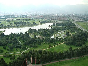
Aerial view of Simón Bolívar Park
|
|
| Location in a map of Bogotá | |
| Location | Bogotá, Colombia |
| Coordinates | 4°39′29″N 74°5′38″W / 4.65806°N 74.09389°WCoordinates: 4°39′29″N 74°5′38″W / 4.65806°N 74.09389°W |
| Area | 400 hectares (988 acres) |
| Created | 1979 |
| Operated by | Mayor's Office of Bogotá |
| Status | Open all year |
The Simón Bolívar Metropolitan Park, best known as the Simón Bolívar Park, is a greenspace and entertainment and sports complex located in the middle of the city of Bogotá, Colombia.
The park is named after the Latin American Liberator Simón Bolívar. The park is located in the locality of Teusaquillo and is managed by the District Institute of Recreation and Sport (Instituto Distrital de Recreacion y Deporte - IDRD). The park is one of the most popular urban parks in the city of Bogotá.
The park features a lake in which people can rent paddle boats and a large space for concerts and events capable of holding 140.000 people.
The construction of Simón Bolívar Park started in 1966. In 1968 the city of Bogotá built a temple to commemorate the 39th International Eucharistic Congress to which the pope Paul VI was a part of. This temple was named Eucharistic Temple. At the time the lake already existed as a natural feature. In 1986 a second temple was built for the reception of Pope John Paul II. The park was officially named under the Law 31 of 1979 in commemoration of the bicentennial of the birth of Latin American leader Simón Bolívar.
Colombian architect Arturo Robledo Ocampo designed in 1982 the details of new improvements to the park which at the time was far from an actual recreational space. Ocampo developed the plans for tree growing areas, the central plaza and also designed the water supply and structures such as channels and walls. In 1983 the Events Plaza was finally built. 3300 trees were planted and a pedestrian bridge that linked the park with the Children's Museum was inaugurated. In 1995 the pedestrian pathways were made bigger from 5 meters to 10 meters wide. The stage area of the Events Plaza was closed in the perimeters and the illumination was improved. Three new access points were added.
Since 1996 new social programs have been created in order to make the park an events center. This include as of now the Summer Festival, and the Rock to the park festival making it the axis of recreational activities for the city.
...
Wikipedia

