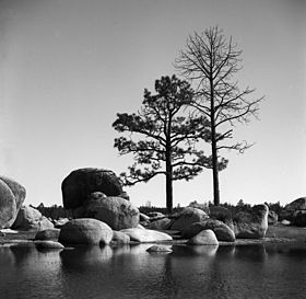
Sierra de Juarez
| Sierra de Juárez | |
|---|---|

Laguna Hanson, in Constitution 1857 National Park
|
|
| Geography | |
| Range coordinates | 31°18′N 115°20′W / 31.3°N 115.33°WCoordinates: 31°18′N 115°20′W / 31.3°N 115.33°W |
The Sierra de Juárez, also known as the Sierra Juarez, is a mountain range located in Tecate Municipality and northern Ensenada Municipality, within northern Baja California state of northwestern Mexico.
It is a major mountain range in the long Peninsular Ranges System, that extends from Southern California down the Baja California Peninsula into Baja California Sur state.
The Sierra de Juárez begins just south of the international frontier with California and extends about 140 kilometres (87 mi) southwards. The highest peak in the range rises to about 1,980 meters (6,500 ft) elevation at 31° 30′ 34″ North Latitude and 115° 32′ 5″ West Longitude. The Laguna Mountains (U.S.) are on the north, and the Sierra de San Pedro Mártir (México) are on the south. The Sierra forms part of the Baja California Peninsular Ranges.
According to the Mexican government agency, CONABIO, the Sierra de Juárez occupies a total area of 4,568 square kilometres (1,764 sq mi) approximately 140 kilometres (87 mi) long and averaging about 33 kilometres (21 mi) wide. On the east the Sierra de Juárez rises sharply from the desert valley containing the Laguna Salada Fault, a southern extension of the San Andres Fault. The western slope of the Sierra is more gentle.
The range is the location of the southern tip of the Great Basin Divide at a triple watershed point of the Great Basin (northern), the Pacific Ocean (western), and Gulf of California (eastern) watersheds.
...
Wikipedia

