Sierra de Guadarrama
| Sierra de Guadarrama | |
| Sub-Range | |
|
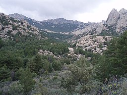
Peaks of La Pedriza
|
|
| Country | Spain |
|---|---|
| Region | Iberian Peninsula |
| Part of | Sistema Central |
| Highest point | Peñalara |
| - elevation | 2,428 m (7,966 ft) |
| - coordinates | 40°51′00″N 03°57′00″W / 40.85000°N 3.95000°W |
| Geology | Granite |
The Sierra de Guadarrama (Guadarrama Mountains) is a mountain range forming the main eastern section of the Sistema Central, the system of mountain ranges along the centre of the Iberian Peninsula. It is located between the systems Sierra de Gredos in the province of Ávila, and Sierra de Ayllón in the province of Guadalajara.
The range runs southwest—northeast, extending from the province of Ávila in the southwest, through the Community of Madrid, to the province of Segovia in the northeast. The range measures approximately 80 kilometres (50 mi) in length. Its highest peak is Peñalara, 2,428 metres (7,966 ft) in elevation.
The flora of the Sierra de Guadarrama is characterized in the higher elevation Atlantic vegetation region with Juniper groves, montane grasslands, Spanish broom thickets, pine forests, and Pyrenean Oaks forests; and in the lower elevation Mediterranean vegetation region by Holm oak forests. while the pastures around the summits are fringed by juniper and Spanish broom shrubs. The mountains abound with a variety of wildlife such as Spanish ibex, roe deer, fallow deer, wild boar, badger, various types of weasel, European wild cat, fox and hare. The area is also rich in birdlife including birds of prey such as the Spanish imperial eagle and the Eurasian black vulture.
...
Wikipedia

