Siddapur, Uttara Kannada
|
Siddapura ಸಿದ್ದಾಪುರ |
|
|---|---|
| Town | |

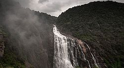
Unchalli Falls Siddapur
|
|
| Location in Karnataka, India | |
| Coordinates: 14°20′49″N 74°53′38″E / 14.347°N 74.894°ECoordinates: 14°20′49″N 74°53′38″E / 14.347°N 74.894°E | |
| Country | India |
| State | Karnataka |
| District | Uttara Kannada |
| Region | Malenadu |
| Elevation | 564 m (1,850 ft) |
| Population (2011) | |
| • Total | 97,322 |
| Languages | |
| • Official | Kannada |
| Time zone | IST (UTC+5:30) |
| PIN | 581 355 |
| Telephone code | +91-8389 |
| ISO 3166 code | IN-KA |
| Vehicle registration | KA 31 |
| Website | karnataka |
Siddapura Kannada: ಸಿದ್ದಾಪುರ) is a town and the headquarters of Siddapur taluk, located in the Uttara Kannada district of the state of Karnataka in southern India. It is nestled among the Western Ghats. The town is surrounded by forest and the region is popular for a large number of waterfalls. Sirsi is the Nearest Large City. Adike (Areca nut) is the primary crop grown in the villages that surround the town.
As of 2001[update], Siddapura had a population of 14,049. Males were 51% of the population and females 49%. The average literacy rate is 82% (male 88%, female 82%). 11% of the population is under 6 years of age. Kannada is the most common language.
Siddapura's primary ethnic and religious groups are Lingayats, Namadhari Naiks, Gudigars, Gaud Saraswat Brahmins, Halakki Vokkaligas, Havyaks, Kurubas, Madivals, Christians, Daivajnas, Muslims, and Marathas.
Bus service is provided by KSRTC and a few private bus operators. These buses connect Siddapur to elsewhere in Karnataka, as well as a few buses to other states. Siddapura is well connected by road to the surrounding area.
...
Wikipedia


