Shottesbrook
| Shottesbrooke | |
|---|---|
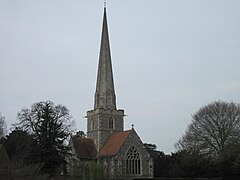
 St John the Baptist Church at Shottesbrooke Park |
|
| Shottesbrooke shown within Berkshire | |
| Area | 5.64 km2 (2.18 sq mi) |
| Population | 141 (2011 Civil Parish) |
| • Density | 25/km2 (65/sq mi) |
| OS grid reference | SU8477 |
| • London | 28.9 miles (46.5 km) |
| Civil parish |
|
| Unitary authority | |
| Ceremonial county | |
| Region | |
| Country | England |
| Sovereign state | United Kingdom |
| Post town | MAIDENHEAD |
| Postcode district | SL6 |
| Dialling code | 01628 |
| Police | Thames Valley |
| Fire | Royal Berkshire |
| Ambulance | South Central |
| EU Parliament | South East England |
| UK Parliament | |
Shottesbrooke /ʃɒts.brʊk/ is a village and civil parish administered by the unitary authority of the Royal Borough of Windsor and Maidenhead in the English county of Berkshire. The village is mostly rural: 88% covered by agriculture or woodland and had a population of 141 at the 2011 census.
The parish saw an 8% decrease in population between 2001 and 2011 according to the UK census, from 154 in 2001 to 141 in 2011. This contrasts to an increase in the borough as a whole. The parish had 61 dwellings (i.e. homes) in 2011. The majority (4.972 km2 (1.920 sq mi)) of land is defined as agricultural or other greenspace, in the land use statistics of January 2005 and 0.149 km2 (0.058 sq mi) 14.9 hectares (37 acres) fell within either road or rail use. Gardens accounted for 0.054 square kilometres (0.021 sq mi) and water 0.027 km2 (0.010 sq mi) all of which was in tributaries or ponds rather than lakes or rivers. The remaining three categories were in decreasing overall size: other land use, non-domestic buildings and domestic buildings.
Shottesbrooke is a parish between Waltham St Lawrence on the west and White Waltham on the east. They were originally one place, Waltham, which was divided in the Saxon era. Today, as always, it is mostly farmland with some large areas of woodland in between, particularly the Great Wood. The hamlet of Cold Harbour is in the very north of the parish, with Shottesbrooke itself in the central area, between Shottesbrooke Park and Smewins' Farm, where the B3024 runs through the region. The M4 motorway crosses the south-east corner of the parish.
...
Wikipedia

