Shire of Chapman Valley
|
Shire of Chapman Valley Western Australia |
|||||||||||||
|---|---|---|---|---|---|---|---|---|---|---|---|---|---|

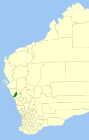
Location in Western Australia
|
|||||||||||||
| Population | 1,214 (2013 est) | ||||||||||||
| • Density | 0.30620/km2 (0.7931/sq mi) | ||||||||||||
| Established | 1901 | ||||||||||||
| Area | 3,964.7 km2 (1,530.8 sq mi) | ||||||||||||
| President | John Collingwood | ||||||||||||
| Council seat | Nabawa | ||||||||||||
| Region | Mid West | ||||||||||||
| State electorate(s) | Moore | ||||||||||||
| Federal Division(s) | Durack | ||||||||||||
 |
|||||||||||||
| Website | Shire of Chapman Valley | ||||||||||||
|
|||||||||||||
The Shire of Chapman Valley is a local government area located in the Mid West region of Western Australia, immediately northeast of the city of Geraldton and about 440 kilometres (273 mi) north of Perth, the state capital. The Shire covers an area of 3,965 square kilometres (1,531 sq mi) and its seat of government is the small town of Nabawa.
The Upper Chapman Road District was established on 25 January 1901. On 28 March 1958, it was renamed to Chapman Valley Road District and on 1 July 1961, it became a Shire under the Local Government Act 1960.
The Shire has been divided into 3 wards, each with 3 councillors:
Coordinates: 28°30′00″S 114°47′20″E / 28.500°S 114.789°E
...
Wikipedia
