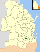
Shire of Cambooya
|
Shire of Cambooya Queensland |
|||||||||||||||
|---|---|---|---|---|---|---|---|---|---|---|---|---|---|---|---|

Location within Queensland
|
|||||||||||||||
| Population | 5,652 (2006 census) | ||||||||||||||
| • Density | 8.8520/km2 (22.927/sq mi) | ||||||||||||||
| Established | 1914 | ||||||||||||||
| Area | 638.5 km2 (246.5 sq mi) | ||||||||||||||
| Council seat | Greenmount | ||||||||||||||
| Region | Darling Downs | ||||||||||||||
 |
|||||||||||||||
| Website | Shire of Cambooya | ||||||||||||||
|
|||||||||||||||
The Shire of Cambooya was a local government area in the Darling Downs region of Queensland, Australia, immediately south of the regional city of Toowoomba. The shire, administered from the town of Greenmount, covered an area of 638.5 square kilometres (246.5 sq mi), and existed as a local government entity from 1914 until 2008, when it amalgamated with several other councils in the Toowoomba area to form the Toowoomba Region.
Its main pursuits included dairying and beef cattle, pig production, horse spelling and breeding, grain growing and vegetable production. The northern section, containing rural-residential suburbs such as Vale View and Hodgson Vale, are commuter districts within 12 kilometres (7 mi) of Toowoomba's urban core.
The Shire of Cambooya was created by severance from the Shire of Clifton. It absorbed part of the Tarampa Shire in 1915, and part of Drayton in 1949.
Cambooya had four divisions electing two councillors each, with a separately elected mayor.
On 15 March 2008, under the Local Government (Reform Implementation) Act 2007 passed by the Parliament of Queensland on 10 August 2007, the Shire of Cambooya merged with the City of Toowoomba and the Shires of Clifton, Crows Nest, Jondaryan, Millmerran, Pittsworth and Shire of Rosalie to form the Toowoomba Region.
...
Wikipedia
