Shirataka, Yamagata
|
Shirataka 白鷹町 |
|||
|---|---|---|---|
| Town | |||

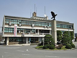
Shirataka Town Hall
|
|||
|
|||
 Location of Shirataka in Yamagata Prefecture |
|||
| Coordinates: 38°11′N 140°06′E / 38.183°N 140.100°ECoordinates: 38°11′N 140°06′E / 38.183°N 140.100°E | |||
| Country | Japan | ||
| Region | Tōhoku | ||
| Prefecture | Yamagata | ||
| District | Nishiokitama | ||
| Area | |||
| • Total | 157.74 km2 (60.90 sq mi) | ||
| Population (November 2013) | |||
| • Total | 14,638 | ||
| • Density | 92.8/km2 (240/sq mi) | ||
| Time zone | Japan Standard Time (UTC+9) | ||
| - Tree | Sakura | ||
| - Flower | Kobushi Magnolia | ||
| - Bird | Hawk | ||
| -Fish | Ayu | ||
| Phone number | 0238-85-2111 | ||
| Address | 833 Arata, Shirataka-chō, Yamagata-ken 992-0892 | ||
| Website | |||
Shirataka (白鷹町 Shirataka-machi?) is a town located in Nishiokitama District, Yamagata Prefecture, Japan.
As of November 2013, the town had an estimated population of 8,278 and a population density of 11.2 persons per km². The total area was 737.55 square kilometres (285 sq mi).
Shirataka is located in southern Yamagata Prefecture, with the Mogami River running through the town. The Asahi Mountains border the town to the east and west.
Shirataka has a Humid continental climate (Köppen climate classification Dfa) with large seasonal temperature differences, with warm to hot (and often humid) summers and cold (sometimes severely cold) winters. Precipitation is significant throughout the year, but is heaviest from August to October.
The area of present-day Shirataka was part of ancient Dewa Province. After the start of the Meiji period, the area became part of Nishiokitama District, Yamagata Prefecture. The village of Shirataka was established on April 1, 1889. It was elevated to town status on October 1, 1954 by merger with the neighboring town of Arata and villages of Higashine, Ayukai, Jūō, and Koguwa.
The economy of Shirataka is based on agriculture.
...
Wikipedia


