Shingō, Aomori
|
Shingō 新郷村 |
|||
|---|---|---|---|
| Village | |||

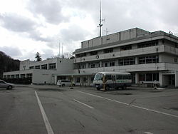
Shingō Village Office
|
|||
|
|||
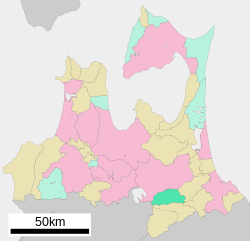
 Location of Shingō in Aomori Prefecture |
|||
| Coordinates: 40°27′49.19″N 141°10′27.53″E / 40.4636639°N 141.1743139°ECoordinates: 40°27′49.19″N 141°10′27.53″E / 40.4636639°N 141.1743139°E | |||
| Country | Japan | ||
| Region | Tōhoku | ||
| Prefecture | Aomori Prefecture | ||
| District | Sannohe | ||
| Area | |||
| • Total | 150.77 km2 (58.21 sq mi) | ||
| Population (October 2016) | |||
| • Total | 2,495 | ||
| • Density | 16.5/km2 (43/sq mi) | ||
| Time zone | Japan Standard Time (UTC+9) | ||
| - Tree | Aesculus | ||
| - Flower | Asian skunk cabbage | ||
| Phone number | 0178-78-2111 | ||
| Address |
039-0801 |
||
| Website | www |
||
Shingō (新郷村 Shingō-mura?) is a village located in Sannohe District of south-central Aomori Prefecture in the Tōhoku region of Japan. As of 1 October 2016[update], the village has an estimated population of 2,495 and a population density of 16.5 persons per km². Its total area is 150.77 square kilometres (58.21 sq mi). The village promotes itself as the home of the Grave of Christ (キリストの墓 Kirisuto no Haka?) after a local legend.
Shingō is in south-central Aomori Prefecture, east of Lake Towada. Much of the village is mountainous, rising to over 1000 meters in altitude near the border with Akita Prefecture. The village has a cold Humid continental climate characterized by cool short summers and long cold winters with very heavy snowfall (Köppen climate classification Dfa). The average annual temperature in Shingō is 8.7 °C. The average annual rainfall is 1342 mm with September as the wettest month.The temperatures are highest on average in August, at around 22.2 °C, and lowest in January, at around -3.7 °C.
...
Wikipedia


