Shimokitayama, Nara
|
Shimokitayama 下北山村 |
|||
|---|---|---|---|
| Village | |||

Shimokitayama Village Office
|
|||
|
|||
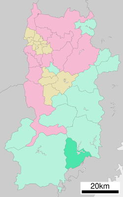
 Location of Shimokitayama in Nara Prefecture |
|||
| Location in Japan | |||
| Coordinates: 34°0′N 135°57′E / 34.000°N 135.950°ECoordinates: 34°0′N 135°57′E / 34.000°N 135.950°E | |||
| Country | Japan | ||
| Region | Kansai | ||
| Prefecture | Nara Prefecture | ||
| District | Yoshino | ||
| Area | |||
| • Total | 133.53 km2 (51.56 sq mi) | ||
| Population (October 1, 2016) | |||
| • Total | 855 | ||
| • Density | 6.4/km2 (17/sq mi) | ||
| Time zone | Japan Standard Time (UTC+9) | ||
| Website | www |
||
Shimokitayama (下北山村 Shimokitayama-mura?) is a village located in Yoshino District, Nara Prefecture, Japan.
As of October 2016, the village has an estimated population of 855 and a density of 6.4 persons per km². The total area is 133.53 km².
Bordering on Kamikitayama to the north and Totsukawa to the west, it is the southeasternmost region in Nara Prefecture. It shares a border to the east with Kumano, Mie Prefecture, and to the south, with Kitayama, Wakayama Prefecture.
Shimokitayama is composed of seven main hamlets, arranged roughly in a circle, and Zenki, which is no longer inhabited but which once housed a religious community of shugendo practitioners, including Jitsukaga.
Roads lead north toward Nara from Ikehara, east toward Kumano from Shimokuwahara, south toward Kitayama from Kamikuwahara, and west toward Totsukawa from Uramukai.
...
Wikipedia


