Shimizu, Hokkaido
|
Shimizu 清水町 |
|||
|---|---|---|---|
| Town | |||
 |
|||
|
|||
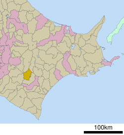
 Location of Shimizu in Hokkaido (Tokachi Subprefecture) |
|||
| Location in Japan | |||
| Coordinates: 43°1′N 142°53′E / 43.017°N 142.883°ECoordinates: 43°1′N 142°53′E / 43.017°N 142.883°E | |||
| Country | Japan | ||
| Region | Hokkaido | ||
| Prefecture | Hokkaido (Tokachi Subprefecture) | ||
| District | Kamikawa (Tokachi) | ||
| Area | |||
| • Total | 402.18 km2 (155.28 sq mi) | ||
| Population (September 30, 2016) | |||
| • Total | 9,784 | ||
| • Density | 24/km2 (63/sq mi) | ||
| Time zone | Japan Standard Time (UTC+9) | ||
| Website | www |
||
The small town of Shimizu (清水町 Shimizu-chō?) is located at the base of the Hidaka Mountain Range in Kamikawa (Tokachi) District, Tokachi Subprefecture, Hokkaido, Japan. The name Shimizu is taken from the Ainu word Pekerebetsu, which means bright clean river. This town of 10,243, (according to the towns 2011 census) primary source of income is through agriculture. This town, like many others in Hokkaido, is decreasing.
As of 2016, the town has an estimated population of 9,784 and a density of 24 persons per km². The total area is 402.18 km².
The town of Shimizu lies within the Tokachi Subprefecture of Hokkaido, Japan. The town lies at the base of the Hidaka Mountain Range and has several towns nearby, including Shikaoi to the North, Shintoku to the West, Hidaka to the South, and Memuro to the East. The geography of the town of Shimizu is mostly flat, with a few low-lying hills to the North and West.
The town of Shimizu began to settle in 1898, with a population of 99 people, working as cultivating farmers. It wasn’t until 1936 that Shimizu gained status as a town. In 1907 a railway connecting Kushiro and Asahikawa was built, thereby connecting Shimizu. At the time, two lines ran through the town: the Tokachi line, and the Tooru Hiraku line. Another improvement that helped put the town on the map was the opening of Nissho Toge, a mountain pass running through the Hidaka Mountains, which opened in 1965. This National Highway, route 274, runs all the way to Hokkaidos capital city, Sapporo.
...
Wikipedia


