Sherman Pass Scenic Byway
| State Route 20 | ||||
|---|---|---|---|---|
| North Cascades Highway | ||||

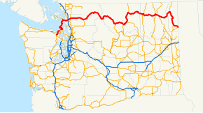
A map of Washington, with the route of SR 20 highlighted in red.
|
||||
| Route information | ||||
| Defined by RCW 47.17.080 | ||||
| Maintained by WSDOT | ||||
| Length: | 436.13 mi (701.88 km) Mileage does not include ferry route |
|||
| Existed: | 1964 – present | |||
| Tourist routes: |
International Selkirk Loop, North Cascades Scenic Byway, Sherman Pass Scenic Byway | |||
| Major junctions | ||||
| West end: |
|
|||
| East end: |
|
|||
| Location | ||||
| Counties: | Jefferson, Island, Skagit, Whatcom, Chelan, Okanogan, Ferry, Stevens, Pend Oreille | |||
| Highway system | ||||
|
||||
|
State Route 20 Spur |
|
|---|---|
| Location: | Anacortes, Washington |
| Existed: | 1964–present |
State Route 20 (SR 20), also known as the North Cascades Highway, is a state highway that traverses the U.S. state of Washington. It is the state's longest highway, traveling 436 miles (702 km) across the northern areas of Washington, from U.S. Route 101 (US 101) at Discovery Bay on the Olympic Peninsula to US 2 near the Idaho state border in Newport. The highway travels across Whidbey Island, North Cascades National Park, the Okanagan Highland, the Kettle River Range, and the Selkirk Mountains. SR 20 connects several major north–south state highways, including Interstate 5 (I-5) in Burlington, US 97 through the Okanogan–Omak area, SR 21 in Republic, and US 395 from Kettle Falls to Colville.
...
Wikipedia

