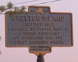
Shelter Island (town), New York
| Shelter Island, New York | ||
|---|---|---|
| Town | ||
| Town of Shelter Island | ||
 |
||
|
||
 |
||
| Coordinates: 41°4′41″N 72°21′3″W / 41.07806°N 72.35083°WCoordinates: 41°4′41″N 72°21′3″W / 41.07806°N 72.35083°W | ||
| Country | United States | |
| State | New York | |
| County | Suffolk | |
| Government | ||
| • Type | Civil Township | |
| • Supervisor | James Dougherty (D) | |
| Area | ||
| • Total | 27.1 sq mi (70.2 km2) | |
| • Land | 12.1 sq mi (31.4 km2) | |
| • Water | 15.0 sq mi (38.7 km2) | |
| Elevation | 56 ft (17 m) | |
| Population (2010) | ||
| • Total | 2,392 | |
| • Density | 88/sq mi (34/km2) | |
| Time zone | Eastern (EST) (UTC-5) | |
| • Summer (DST) | EDT (UTC-4) | |
| ZIP code | 11964, 11965 | |
| Area code(s) | 631 Exchange: 749 | |
| GNIS feature ID | 0965037 | |
| Website | www |
|
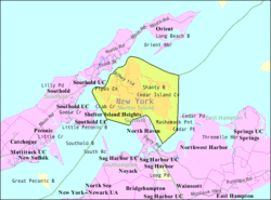
Shelter Island is a town and island at the eastern end of Long Island in the U.S. state of New York. It is part of Suffolk County, although it is separated from the rest of the county by water. The population was 2,392 at the 2010 census.
Shelter Island is nestled between the North and South Forks of Long Island. It is surrounded on three sides by Shelter Island Sound and on the fourth side by Gardiners Bay. It can be reached via ferry from Greenport to the north (approximately 8-minute trip) or from North Haven to the south (approximately 5-minute trip). New York State Route 114 runs through the island.
Shelter Island is around 8,000 acres (32 km2) in size. Vast tracts are protected wetlands, a nature preserve marshland. Nearly one-third of the island is owned by The Nature Conservancy to be preserved in a wild state. The Preserve has four nature and bird-watching trails, varying in length from 1.5 miles (2.4 km) to 11 miles (18 km), as well as a barrier-free Braille trail for the visually impaired.
According to the United States Census Bureau, Shelter Island has a total area of 27.1 square miles (70.2 km2), of which 12.1 square miles (31.4 km2) is land and 15.0 square miles (38.7 km2) (55.20%) is water.
As of the 2000 census, there were 2,228 people, 996 households, and 656 families residing in the town. However, during the summer months the population can exceed 8,000. The population density was 183.6 people per square mile (70.9/km2). There were 2,370 housing units at an average density of 195.3 per square mile (75.4/km2). The racial makeup of the town was 96.32% White, 0.72% Black or African American, 0.04% Native American, 0.49% Asian, 0.09% from other races, and 2.33% from two or more races. Hispanic or Latino of any race were 2.38% of the population.
...
Wikipedia


