Shelby, Ohio
| Shelby, Ohio | |
|---|---|
| City | |

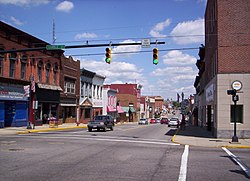
West Main Street in downtown Shelby looking east at the intersection of Gamble Street.
|
|
 Location of Shelby, Ohio |
|
 Location of Shelby in Richland County |
|
| Coordinates: 40°53′5″N 82°39′34″W / 40.88472°N 82.65944°WCoordinates: 40°53′5″N 82°39′34″W / 40.88472°N 82.65944°W | |
| Country | United States |
| State | Ohio |
| County | Richland |
| Founded | 1834 |
| Incorporated | 1853 (village) |
| - | 1921 (city) |
| Government | |
| • Mayor | Steven L. Schag |
| Area | |
| • Total | 6.49 sq mi (16.81 km2) |
| • Land | 6.35 sq mi (16.45 km2) |
| • Water | 0.14 sq mi (0.36 km2) |
| Elevation | 1,102 ft (336 m) |
| Population (2010) | |
| • Total | 9,317 |
| • Estimate (2012) | 9,171 |
| • Density | 1,467.2/sq mi (566.5/km2) |
| Time zone | Eastern (EST) (UTC-5) |
| • Summer (DST) | EDT (UTC-4) |
| ZIP code | 44875 |
| Area code(s) | 419 |
| FIPS code | 39-72102 |
| GNIS feature ID | 1065313 |
| Website | shelbycity |
Shelby is a city in Richland County in the U.S. state of Ohio, northwest of the city of Mansfield. It is part of the Mansfield, Ohio Metropolitan Statistical Area. The population was 9,317 as of the 2010 census.
Shelby was originally called Gamble's Mills, and under the latter name was platted in 1834.
Shelby is located at 40°53′5″N 82°39′34″W / 40.88472°N 82.65944°W (40.884645, -82.659529), along the Black Fork of the Mohican River.
According to the United States Census Bureau, the city has a total area of 6.49 square miles (16.81 km2), of which 6.35 square miles (16.45 km2) is land and 0.14 square miles (0.36 km2) is water. Much of the water area consists of the Black Fork of the Mohican River, which flows through downtown; its location makes the city vulnerable to floods.
As of the census of 2000, there were 9,821 people, 4,073 households, and 2,667 families residing in the city. The population density was 1,949.3 people per square mile (752.4/km²). There were 4,330 housing units at an average density of 859.4 per square mile (331.7/km²). The racial makeup of the city was 98.40% White, 0.14% African American, 0.18% Native American, 0.35% Asian, 0.37% from other races, and 0.56% from two or more races. Hispanic or Latino of any race were 1.02% of the population.
...
Wikipedia
