Sheffield, Illinois
| Sheffield | |
| Village | |
|
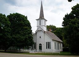
Danish Church in Sheffield
|
|
| Country | United States |
|---|---|
| State | Illinois |
| County | Bureau |
| Townships | Concord, Mineral |
| Coordinates | 41°21′21″N 89°44′12″W / 41.35583°N 89.73667°WCoordinates: 41°21′21″N 89°44′12″W / 41.35583°N 89.73667°W |
| Area | 0.71 sq mi (2 km2) |
| - land | 0.71 sq mi (2 km2) |
| - water | 0.00 sq mi (0 km2) |
| Population | 926 (2010) |
| Density | 1,304.2/sq mi (504/km2) |
| Timezone | CST (UTC-6) |
| - summer (DST) | CDT (UTC-5) |
| Postal code | 61361 |
| Area code | 815 |
Sheffield is a village in Bureau County, Illinois, United States. The population was 926 at the 2010 census. It is part of the Ottawa–Streator Micropolitan Statistical Area. Sheffield was founded by Joseph E. Sheffield and Henry Farnam in 1852. Sheffield and Farnam constructed the Chicago and Rock Island Railroad, and the town site was intended as a coaling station for trains. According to Farnam, he and Sheffield flipped a coin to see for whom the town would be named. A monument to Joseph E. Sheffield, and the Rock Island Railroad stands today in Sheffield's town square. The town is home to a leaking nuclear waste storage facility which closed in 1978.
Sheffield is located at 41°21′21″N 89°44′12″W / 41.35583°N 89.73667°W (41.355915, -89.736672).
According to the 2010 census, Sheffield has a total area of 0.71 square miles (1.84 km2), all land.
As of the census of 2000, there were 946 people, 385 households, and 269 families residing in the village. The population density was 1,263.5 people per square mile (487.0/km²). There were 418 housing units at an average density of 558.3 per square mile (215.2/km²). The racial makeup of the village was 98.31% White, 0.11% African American, 0.21% Asian, 0.21% Pacific Islander, 0.21% from other races, and 0.95% from two or more races. Hispanic or Latino of any race were 0.63% of the population.
...
Wikipedia


