Shebelle
| Shebelle River | |
|---|---|

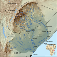
Map of the Jubba/Shebelle drainage basin
|
|
| Country | Ethiopia, Somalia |
| Basin features | |
| Main source | near 7°13′12″N 39°27′59″E / 7.2201°N 39.4665°E |
| River mouth | occasionally continues into the Jubba River, usually dries up near 0°09′57″N 42°46′22″E / 0.1659°N 42.7727°ECoordinates: 0°09′57″N 42°46′22″E / 0.1659°N 42.7727°E |
The Shebelle River (Somali: Webi Shabeelle, Italian: Uebi Scebeli) begins in the highlands of Ethiopia, and then flows southeast into Somalia towards Mogadishu. Near Mogadishu, it turns sharply southwest, where it follows the coast. Below Mogadishu, the river becomes seasonal. During most years, the river dries up near the mouth of the Jubba River, while in seasons of heavy rainfall, the river actually reaches the Jubba and thus the Indian Ocean.
The Shebelle river's name is derived from the Somali term Wabi Shabeelle, meaning "Leopard/Tiger River". The Somali administrative regions consisting of Shabeellaha Dhexe and Shabeellaha Hoose are also named after the river.
The Shebelle has a number of tributaries, both seasonal and permanent rivers. They include:
The Fafen only reaches the Shebelle in times of heavy rainfall; its stream usually ends before reaching the main river.
The source of the Shebelle River is venerated by both the Arsi Oromo and the Sidamo people. It is surrounded by a sacred enclosure wooded with juniper trees, which as of 1951 was under the protection of a Muslim member of the Arsi.
In 1989, with the help of Soviet engineers, the Melka Wakena dam was built on the upper reaches of the Shebelle River in the Bale Mountains. Producing 153 megawatts, this dam is Ethiopia’s largest hydroelectric generator.
...
Wikipedia
