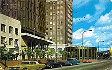
Shattuck Avenue

A 1973 color photocrome postcard of the Downtown Berkeley BART Station and Berkeley Chamber of Commerce building
|
|
| Location | Berkeley, California and Oakland, California |
|---|---|
| Coordinates | 37°52′20″N 122°16′06″W / 37.8721°N 122.2684°WCoordinates: 37°52′20″N 122°16′06″W / 37.8721°N 122.2684°W |
Shattuck Avenue is a major city street running north-south through Berkeley, California and Oakland, California. At its southern end, the street branches from Telegraph Avenue in Oakland's Temescal district, then ends at Indian Rock Park in the Berkeley Hills to the north. Shattuck Avenue is the main street of Berkeley, forming the spine of that city's downtown, and the site of the Gourmet Ghetto in North Berkeley. The street was named for Francis Kittredge Shattuck, an early landowner and booster who later served as Mayor of Oakland. Shattuck was largely responsible for the original construction of the road as well as for a railroad built along its route.
During the Mexican era, a trail or road ran between the homes of the Peralta brothers, Domingo and Vicente. Domingo made his home along Codornices Creek near what is today the intersection of Sacramento and Hopkins Streets in Berkeley. Vicente's home was situated along Temescal Creek near what is today the intersection of 55th Street and Telegraph Avenue in North Oakland. The route of this early predecessor road, which came to be called the "Temescal Road", is depicted on the first official plat map of the area, Kellersberger's Map. A trace of it survives today as Racine Avenue in North Oakland.
During the 1850s, Francis Shattuck and three others laid claim to four adjoining strips of land in what is now downtown Berkeley. The dividing line between the parcels claimed by Shattuck and his brother-in-law George Blake became the alignment of a new county road whose construction the Board of Supervisors assigned to Francis Shattuck, a member of the board. The new road was laid out from where Strawberry Creek intersected the old Temescal Road, thence along the new alignment, extending southward to a gore point intersection with the Telegraph Road (today's Telegraph Avenue). The road became known as "Shattuck's Road". Francis Shattuck built his new home above the north bank of Strawberry Creek at the northern terminus of the county road, which was also the northern bound of Shattuck's claim, along the alignment of what is now Addison Street. The creek and Shattuck's home were situated along what is now Allston Way.
...
Wikipedia
