Sharavati
| Sharavati | |
| ಶರಾವತಿ ನದಿ | |
| River | |
|
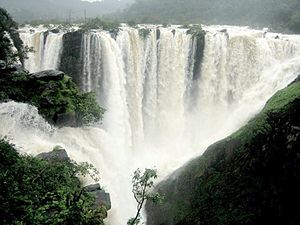
Jog Falls formed by the Sharavati river.
|
|
| Country | India |
|---|---|
| State | Karnataka |
| Cities | Sagar, Honnavar |
| Source | Ambutheertha |
| - location | Thirthahalli Taluk, Shimoga, Karnataka |
| - elevation | 730 m (2,395 ft) |
| - coordinates | 13°47′33″N 75°10′35″E / 13.79250°N 75.17639°E |
| Mouth | Arabian Sea |
| - location | Honnavar, Uttara Kannada, Karnataka |
| - elevation | 0 ft (0 m) |
| - coordinates | 14°17′57″N 74°25′25″E / 14.29917°N 74.42361°ECoordinates: 14°17′57″N 74°25′25″E / 14.29917°N 74.42361°E |
| Length | 128 km (80 mi) |
| Basin | 2,985 km2 (1,153 sq mi) |
Sharavati is a river which originates and flows entirely within the state of Karnataka in India. It is one of the few westward flowing rivers of India and a major part of the river basin lies in the Western Ghats. The famous Jog Falls, located about 24 km from Sagara, are formed by this river. The river itself and the region around it are rich in biodiversity and are home to many rare species of flora and fauna.
The river Sharavati originates at a place called Ambutheertha in the Thirthahalli taluk. According to a legend of the times of Ramayana, this is the place where the Hindu God Rama broke a bow to win the hand of Sita The total length of the river is around 128 km (80 mi) and it joins the Arabian Sea at Honnavar in Uttara Kannada district. On its way, the Sharavati forms the Jog Falls where the river falls from a height of 253 mts. The river is dammed at Linganamakki and the portion of the river above the dam is upstream and the remaining is downstream. The major tributaries of the river are Nandihole, Haridravathi, Mavinahole, Hilkunji, Yennehole, Hurlihole, and Nagodihole. Sharavati river basin falls into two districts of Karnataka namely Uttara Kannada and Shimoga. The upstream river basin is extended to two taluks i e Hosanagar and Sagar. The entire basin has an area of 2,985.66 km2 (1,153 sq mi). with upstream being 1,988.99 km2 (768 sq mi). and the downstream being 996.67 km2 (385 sq mi).
...
Wikipedia

