Shaniko, Oregon
| Shaniko, Oregon | |
|---|---|
| City | |

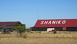
City name written on barn in Shaniko
|
|
| Nickname(s): Oregon's Best Known Ghost Town | |
 Location in Oregon |
|
| Coordinates: 45°0′11″N 120°45′11″W / 45.00306°N 120.75306°WCoordinates: 45°0′11″N 120°45′11″W / 45.00306°N 120.75306°W | |
| Country | United States |
| State | Oregon |
| County | Wasco |
| Incorporated | 1901 |
| Government | |
| • Mayor | Goldie Roberts |
| Area | |
| • Total | 0.50 sq mi (1.29 km2) |
| • Land | 0.50 sq mi (1.29 km2) |
| • Water | 0 sq mi (0 km2) |
| Elevation | 3,343 ft (1,019 m) |
| Population (2010) | |
| • Total | 36 |
| • Estimate (2012) | 37 |
| • Density | 72.0/sq mi (27.8/km2) |
| Time zone | Pacific (UTC-8) |
| • Summer (DST) | Pacific (UTC-7) |
| ZIP code | 97057 |
| Area code(s) | 541 |
| FIPS code | 41-66700 |
| GNIS feature ID | 1126791 |
| Website | http://www.shaniko.com |
Shaniko (/ˈʃænᵻkoʊ/, SHAN-i-koh) is a city located in Wasco County, Oregon, United States, on U.S. Route 97 and about 8 miles (13 km) north of Antelope. The population was 36 at the 2010 census.
Shaniko is in Wasco County, in north-central Oregon, at the intersection of U.S. Route 97 and Oregon Route 218. The city is 69 miles (111 km) north of Redmond and 131 miles (211 km) east of Portland. According to the United States Census Bureau, the city has a total area of 0.50 square miles (1.29 km2), all of it land.
The city is at an elevation of 3,343 feet (1,019 m). On the high plateau on which Shaniko was built, the soil is thin and the vegetation sparse, consisting mainly of sagebrush, bunchgrass, and occasional junipers. Many peaks of the Cascade Range, including Hood, Jefferson, Adams, St. Helens and Rainier, are visible from the city.
...
Wikipedia
