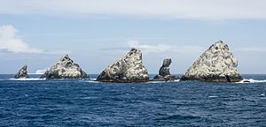
Shag Rocks, South Georgia

The Shag Rocks
|
|
| Geography | |
|---|---|
| Coordinates | 53°33′S 42°02′W / 53.550°S 42.033°W |
| Archipelago | South Georgia |
| Area | 20 ha (49 acres) |
| Highest elevation | 75 m (246 ft) |
| Administration | |
| Demographics | |
| Population | 0 |
| Additional information | |
| Also Claimed by Argentina | |
The Shag Rocks (Spanish: Islas Aurora) are six small islands in the westernmost extreme of South Georgia, 240 km (150 mi) west of the main island of South Georgia and 1,000 km (620 mi) off the Falkland Islands. The Shag Rocks are located at 53°33′S 42°02′W / 53.550°S 42.033°W. 16 kilometres (9.9 mi) further southeast is Black Rock. Black Rock is located at 53°39′S 41°48′W / 53.650°S 41.800°W.
The Shag Rocks cover a total area of less than 20 hectares (49 acres). Situated on the South Georgia Ridge, they have a peak elevation above sea level of 75 metres (246 ft), and stand in water approximately 319 metres (1,047 ft) deep. Temperatures average −1.2 °C (29.8 °F), rarely climbing above 15 °C (59 °F). There is no significant vegetation.
The main wildlife found on the islands are the South Georgia shags, prions and wandering albatrosses.
...
Wikipedia
