Sewall's Point, Florida
| Sewall's Point, Florida | |
|---|---|
| Town | |

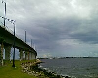
The new Ernest Lyons Bridge, which carries State Road A1A from Hutchinson Island to Sewall's Point
|
|
 Location in Martin County and the state of Florida |
|
| Coordinates: 27°12′N 80°12′W / 27.200°N 80.200°WCoordinates: 27°12′N 80°12′W / 27.200°N 80.200°W | |
| Country |
|
| State |
|
| County | Martin |
| Area | |
| • Total | 4.14 sq mi (10.72 km2) |
| • Land | 1.19 sq mi (3.07 km2) |
| • Water | 2.96 sq mi (7.65 km2) |
| Elevation | 20 ft (6 m) |
| Population (2010) | |
| • Total | 1,996 |
| • Estimate (2016) | 2,180 |
| • Density | 1,839.66/sq mi (710.49/km2) |
| Time zone | Eastern (EST) (UTC-5) |
| • Summer (DST) | EDT (UTC-4) |
| ZIP code | 34996 |
| Area code(s) | 772 |
| FIPS code | 12-65225 |
| GNIS feature ID | 0290880 |
Sewall's Point is a town located on the peninsula of the same name in Martin County, Florida, United States. The population was 1,999 at the 2010 census. As of 2013, the population recorded by the U.S. Census Bureau was 2,078. Both the town and the peninsula are named for Capt. Henry Edwin Sewall (August 22, 1848 – August 1, 1925). It is an eastern suburb of the county seat of Stuart.
Sewall's Point is located at 27°12′N 80°12′W / 27.200°N 80.200°W (27.195,-80.198). It is bordered by water on the south, east, and west due to its peninsula shape of the entire town. On the south and east is the St. Lucie River and to the east is the Indian River Lagoon. On the north it is bordered by unincorporated Jensen Beach
According to the United States Census Bureau, the town has a total area of 4.1 square miles (11 km2), of which 1.2 square miles (3.1 km2) is land and 2.9 square miles (7.5 km2) (70.05%) is water.
As of the census of 2010, there were 1,999 people, 758 households, and 607 families residing in the town. The population density was 1,578.1 people per square mile (610.9/km²). There were 828 housing units at an average density of 671.5 per square mile (259.9/km²). The racial makeup of the town was 98.72% White, 0.41% African American, 0.41% Asian, 0.10% from other races, and 0.36% from two or more races. Hispanic or Latino of any race were 1.39% of the population.
...
Wikipedia
