Sevier County, UT
| Sevier County, Utah | |
|---|---|

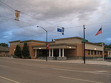
Sevier County Courthouse in Richfield
|
|
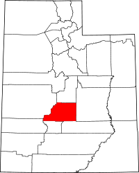
 Location in the U.S. state of Utah |
|
 Utah's location in the U.S. |
|
| Founded | 1865 |
| Named for | The Sevier River |
| Seat | Richfield |
| Largest city | Richfield |
| Area | |
| • Total | 1,918 sq mi (4,968 km2) |
| • Land | 1,911 sq mi (4,949 km2) |
| • Water | 7.8 sq mi (20 km2), 0.4% |
| Population (est.) | |
| • (2015) | 20,984 |
| • Density | 11/sq mi (4/km²) |
| Congressional district | 2nd |
| Time zone | Mountain: UTC-7/-6 |
| Website | www |
Coordinates: 38°45′N 111°48′W / 38.75°N 111.80°W
Sevier County /sɛˈvɪər/ is a county located in the central section of the U.S. state of Utah. As of the 2010 census, the population was 20,802. Its county seat and largest city is Richfield. The county was formed on January 16, 1865, as a split off from Sanpete County to the north. It was named for the Sevier River, which winding path forms its western boundary.
Indigenous peoples migrated into this area by 10,000 years ago, developing different cultures. The Fremont culture of Native Americans occupied the area that is now Sevier County from about 2000 to 700 years before the present. The Clear Creek site contains numerous native petroglyphs from that period.
In Utah, the Numic- (or Shoshonean) speaking peoples of the Uto-Aztecan language family evolved into four distinct groups in the historic period: the Northern Shoshone, Goshute or Western Shoshone, Southern Paiute, and Ute peoples. The central and eastern sections of this territory were occupied primarily by various bands of the Ute. Historic tribes occupied the territory of Utah at the time of the first European contact by Spanish missionaries, and later settlement by European Americans in the 19th century.
...
Wikipedia
