Serras de Sudeste
| Serras de Sudeste | |
|---|---|
| Escudo Sul-Rio-Grandense | |

|
|
| Highest point | |
| Peak | Unclear (possibly Cerro do Sandi) |
| Elevation | 510 m (1,670 ft) |
| Coordinates | 31°30′00″S 53°22′00″W / 31.50000°S 53.36667°W |
| Naming | |
| Translation | Southeastern Mountain Ranges (Portuguese) |
| Pronunciation | Portuguese pronunciation: ['sɛʁɐs dʒi su'dɛstʃi] |
| Geography | |

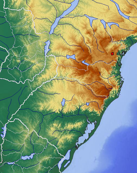
Topographic map of the Southern Region, Brazil. This plateau is located west of Lagoa dos Patos.
|
|
| Country |
|
| State |
|
| Geology | |
| Age of rock | Precambrian |
| Mountain type | Dissected plateau (granite, gneiss) |
Coordinates: 31°30′00″S 53°22′00″W / 31.50000°S 53.36667°W
Serras de Sudeste (English: Southeastern Mountain Ranges) is a dissected plateau, also named Planalto Dissecado de Sudeste (Southeastern Dissected Plateau) or Escudo Sul-Rio-Grandense (Shield of Rio Grande do Sul), located in the southeastern portion of Rio Grande do Sul state in southernmost Brazil, near Uruguay.
This plateau has hills and hillocks covered by grasslands, known as coxilhas (cuchillas in Spanish), whose highest levels do not exceed 600 metres (1,970 feet) in altitude. This plateau was formed in Precambrian time, divided by the Camaquã River in two main units, Serra de Herval and Serra dos Tapes. This region has a triangular area between the cities of Porto Alegre, Jaguarão and Dom Pedrito, approximately.
It is an old plateau, whose tabular relief is preserved only in areas between some rivers.
There are three municipalities, in this region, whose their urban areas are situated above 400 metres (1,312 feet) of elevation: Caçapava do Sul, with 444 metres (1,456 feet), Pinheiro Machado, with 436 metres (1,430 feet), and Encruzilhada do Sul, with 432 metres (1,417 feet). With an urban area above 300 metres (984 feet) of elevation, there are the municipalities of Canguçu, with 386 metres (1,266 feet), Piratini, with 349 metres (1,145 feet), and Santana da Boa Vista, with 306 metres (1,004 feet).
...
Wikipedia
