Serra do Gandarela National Park
| Serra do Gandarela National Park | |
|---|---|
| Parque Nacional da Serra do Gandarela | |
|
IUCN category II (national park)
|
|

Serra do Caraça, part of which is in the park
|
|
| Nearest city | Belo Horizonte, Minas Gerais |
| Coordinates | 20°04′26″S 43°39′48″W / 20.07383°S 43.663397°WCoordinates: 20°04′26″S 43°39′48″W / 20.07383°S 43.663397°W |
| Area | 31,270.83 hectares (77,271.9 acres) |
| Designation | National park |
| Created | 13 October 2014 |
| Administrator | ICMBio |
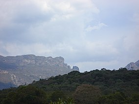
Serra do Gandarela National Park (Portuguese: Parque Nacional da Serra do Gandarela) is a national park in the state of Minas Gerais, Brazil. It protects a mountainous region holding a remnant of Atlantic Forest that is an important source of water for the city of Belo Horizonte.
The Serra do Gandarela is a natural sanctuary about 40 kilometres (25 mi) from Belo Horizonte. Serra do Gandarela National Park covers parts of the municipalities of Caeté (2.37%), Itabirito (10.01%), Mariana (0.23%), Nova Lima (1.99%), Ouro Preto (9.91%, Raposos (10.8%), Rio Acima (19.46%) and Santa Bárbara (45.22%) in the state of Minas Gerais. Part of the park is in the Belo Horizonte metropolitan region. The park has an area of 31,270.83 hectares (77,271.9 acres).
The park is in the Atlantic Forest biome. It holds the largest intact remnant of Atlantic Forest in Minas Gerais, mostly in excellent condition. Waters from the Serra do Gandarela feed the basins of the Das Velhas River, a tributary of the São Francisco River, the Piracicaba River and the Doce River. The Das Velhas provides more than 60% of the water for Belo Horizonte and 45% of the water for the metropolitan region. The water is clean and requires little treatment. The Serra do Gandarela contains over 100 caves. Some support unique species, and some contain archaeological sites.
At the request of a number of civil organisations the Chico Mendes Institute for Biodiversity Conservation (ICMBio) prepared a proposal for creating the park, protecting a large part of the Belo Horizonte water sources, which were seriously threatened by mining for iron ore. The original proposal in 2010 was to protect an area of 38,220 hectares (94,400 acres), but this was reduced before the park was created. Public discussions about the project were started on 10 April 2012.
...
Wikipedia

