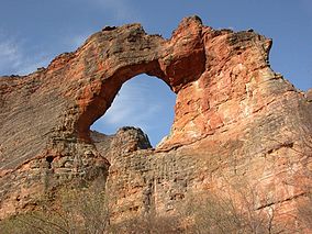
Serra da Capivara National Park
| Serra da Capivara National Park | |
|---|---|
|
IUCN category II (national park)
|
|
 |
|
| Location of Serra da Capivara National Park | |
| Location | Piauí, Brazil |
| Coordinates | 8°40′S 42°33′W / 8.667°S 42.550°WCoordinates: 8°40′S 42°33′W / 8.667°S 42.550°W |
| Area | 1,291.4 km2 (498.6 sq mi) |
| Type | Cultural |
| Criteria | iii |
| Designated | 1991 (15th session) |
| Reference no. | 606 |
| Region | Latin America and the Caribbean |
Serra da Capivara National Park (Portuguese: Parque Nacional Serra da Capivara, IPA: [ˈpaʁki nɐsjoˈnaw ˈsɛʁɐ ðɐ kɐpiˈvaɾɐ], locally [ˈsɛɦɐ da kapiˈvaɾɐ]) is a national park in the Northeastern region of Brazil. The area has many prehistoric paintings.
It is located in northeast state of Piauí, between latitudes 8° 26' 50" and 8° 54' 23" south and longitudes 42° 19' 47" and 42° 45' 51" west. It falls within the municipal areas of São Raimundo Nonato, São João do Piauí, Coronel José Dias and Canto do Buriti. It has an area of 1291.4 square kilometres (319,000 acres).
The Capivara-Confusões Ecological Corridor, created in 2006, links the park to the Serra das Confusões National Park.
The park was created to protect the prehistoric artifacts and paintings found there. It became a World Heritage Site in 1991. Its head archaeologist is Niède Guidon. Its best known archaeological site is Pedra Furada.
This area has the largest concentration of prehistoric sites in the Americas. Scientific studies confirm that the Capivara mountain range was densely populated in the pre-Columbian Era.
...
Wikipedia

