Seney National Wildlife Refuge
| Seney National Wildlife Refuge | |
|---|---|
|
IUCN category Ib (wilderness area)
|
|

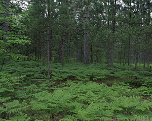
Pinus resinosa forest, with Pteridium aquilinum understorey. Seney National Wildlife Refuge
|
|
|
Location within United States
|
|
| Location | Schoolcraft County, Michigan, United States |
| Nearest city | Seney, Michigan |
| Coordinates | 46°15′N 86°06′W / 46.250°N 86.100°WCoordinates: 46°15′N 86°06′W / 46.250°N 86.100°W |
| Area | 95,264.66 acres (385.5224 km2) |
| Established | 1935 |
| Governing body | U.S. Fish and Wildlife Service |
| Website | Seney National Wildlife Refuge |
The Seney National Wildlife Refuge is a managed wetland in Schoolcraft County in the U.S. state of Michigan. It has an area of 95,212 acres (385 km2). It is bordered by M-28 and M-77. The nearest town of any size is Seney, Michigan. The refuge contains the Seney Wilderness Area and the Strangmoor Bog National Natural Landmark within its boundaries.
While the Seney National Wildlife Refuge is oriented towards maintaining living space for bird life, river otters, beavers, moose, black bears and wolves also live in the refuge. 211 separate species of birds have been logged at Seney, including ducks, bald eagles, trumpeter swans, osprey, sandhill cranes, and common loons. On the western side of the National Wildlife Refuge, a parcel is officially designated as a wilderness with an area of 25,150 acres (102 km2).
The Seney NWR's western wilderness area, designated by federal law as the Seney Wilderness Area, includes the Strangmoor Bog National Natural Landmark. The Strangmoor Bog was landmarked as being the best surviving example in the 48 states of a sub-arctic patterned bog ecosystem, characterized by rapid glacial meltoff from an exposed sandy plain. The friable sand, exposed to the weather, was sculpted by wind and water into parallel strips of dune highland and wetland.
...
Wikipedia

