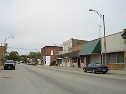
Seneca, Illinois
| Seneca | |
| Village | |
|
Business district in Seneca
|
|
| Country | United States |
|---|---|
| State | Illinois |
| Counties | LaSalle, Grundy |
| Townships | Manlius, Brookfield, Erienna, Norman |
| Elevation | 503 ft (153 m) |
| Coordinates | 41°18′40″N 88°36′35″W / 41.31111°N 88.60972°WCoordinates: 41°18′40″N 88°36′35″W / 41.31111°N 88.60972°W |
| Area | 7.06 sq mi (18 km2) |
| - land | 6.64 sq mi (17 km2) |
| - water | 0.43 sq mi (1 km2) |
| Population | 2,500 (2010) |
| Density | 620.7/sq mi (240/km2) |
| Mayor | David Spicer |
| Timezone | CST (UTC-6) |
| - summer (DST) | CDT (UTC-5) |
| Postal code | 61360 |
| Area code | 815 |
Seneca is a village in LaSalle and Grundy counties in the U.S. state of Illinois. The population was 2,371 at the 2010 census.
The LaSalle County portion of Seneca is part of the Ottawa–Streator Micropolitan Statistical Area, while the small portion that lies in Grundy County is part of the Chicago–Naperville–Joliet Metropolitan Statistical Area.
A French missionary by the name of Father Gabriel de la Ribourde brought Catholicism to the Seneca area 175 years before St. Patrick’s Parish was founded. In 1680, he was traveling with an exploratory party from Quebec when he was ambushed and killed by a band of Kickapoo Indians. A wooden cross marks the spot where Illinois’ first martyr to the Catholic faith is believed to have died (which is located next to St. Patricks Catholic Church). Seneca was first settled by Jeremiah Crotty, an entrepreneur and contractor who helped build the Illinois and Michigan Canal. Crotty built the first residence in 1850 and established the town in 1854 with a post office in his name. Residents retained the name Crotty Town until 1957, when they incorporated the town as Seneca. Before 1957 Seneca was known as Crotty in paper but known locally as Seneca.
Seneca is located at 41°18′40″N 88°36′35″W / 41.31111°N 88.60972°W (41.3111442, -88.6097936).
...
Wikipedia


