Sellwood Bridge
| Sellwood Bridge (new) | |
|---|---|

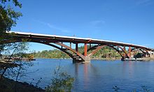
The new bridge in September 2016
|
|
| Coordinates | 45°27′51″N 122°39′56″W / 45.46429°N 122.66564°WCoordinates: 45°27′51″N 122°39′56″W / 45.46429°N 122.66564°W |
| Carries | 2 traffic lanes, pedestrians, cyclists |
| Crosses | Willamette River |
| Locale | Portland, Oregon |
| Owner | Multnomah County |
| Characteristics | |
| Design | Deck arch bridge |
| Total length | 1,976 ft (602 m) |
| Width | 64 ft (20 m) |
| Longest span | 465 ft (142 m) |
| History | |
| Construction cost | $290 million (projected) |
| Opened | February 29, 2016 |
| Statistics | |
| Daily traffic | 30,000 (2005) |
| Sellwood Bridge (old) | |
|---|---|

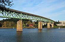
The first Sellwood Bridge in 2010
|
|
| Locale | Portland, Oregon |
| Characteristics | |
| Design | Truss bridge |
| Total length | 1,971 ft (601 m) |
| Width | 28 ft (8.5 m) |
| Longest span | 300 ft (91 m) |
| Clearance below | 75 ft (23 m) |
| History | |
| Opened | December 15, 1925 |
| Closed | February 25, 2016 |
The Sellwood Bridge is a deck arch bridge that spans the Willamette River in Portland, Oregon, in the United States. The current bridge opened in 2016 and replaced a 1925 span that had carried the same name. The original bridge was Portland's first fixed-span bridge and, being the only river crossing for miles in each direction, the busiest two-lane bridge in Oregon. The Sellwood Bridge links the Sellwood and Westmoreland neighborhoods of Portland on the east side with Oregon Route 43/Macadam Avenue on the west side. At its east end it leads to Tacoma Street. The bridge is owned and operated by Multnomah County. The original span of 1925 was a steel truss bridge, while its 2016 replacement is a deck-arch-type bridge.
Designed by Gustav Lindenthal, the first bridge opened on December 15, 1925, at a final cost of $541,000 (equivalent to $6.9 million in 2011). It was 1,971 feet (601 m) long with 75 feet (23 m) of vertical waterway clearance. It had four continuous spans, all of Warren type. The two center spans were 300 feet (91 m) long, and the two outside spans were 246 feet (75 m) each. The girders from the old Burnside Bridge (built in 1894) were reused at each end. The two-lane roadway was 24 feet (7.3 m) wide, and there was a sidewalk along one side.
In the 2000s, discussions began to intensify over the bridge's condition, which had been deteriorating since the 1960s. Upon discovery of cracks in both concrete approaches in January 2004, the weight limit on the bridge was lowered from 32 tons to 10 tons. This caused the diversion of about 1,400 daily truck and bus trips, including 94 daily TriMet bus trips. Over the few years that followed, there was debate on whether the bridge should be replaced, repaired, closed altogether, or closed for automotive traffic (but left open for pedestrians and bicycles). In April 2005, Bechtel gave Multnomah County an unsolicited plan to replace the bridge through a public-private partnership.
...
Wikipedia
