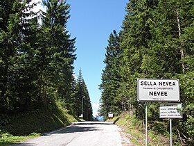
Sella Nevea
| Sella Nevea | |
|---|---|
| Nevee | |

Pass road
|
|
| Elevation | 1,195 m (3,921 ft) |
| Location | Friuli-Venezia Giulia, Italy |
| Range | Julian Alps |
| Coordinates | 46°23′26″N 13°28′32″E / 46.39056°N 13.47556°ECoordinates: 46°23′26″N 13°28′32″E / 46.39056°N 13.47556°E |
|
Location in the Alps
|
|
Sella Nevea (Friulian: Nevee, German: Neveasattel, Slovene: Na Žlebeh), at an altitude of 1,195 m (3,921 ft), is a high mountain pass in the Julian Alps, in the Friuli-Venezia Giulia region of northeast Italy. Sella Nevea also lends its name to a frazione of the Chiusaforte municipality and the nearby Kanin-Sella Nevea Ski Resort.
The mountain pass is located between the Montasio massif in the north and Mt. Kanin in the south, in the Province of Udine near the border with Slovenia. The pass road connects Chiusaforte via the steep Raccolana valley in the southwest with Cave del Predil and Tarvisio in the north.
Sella Nevea is part of a European Watershed dividing the basin of the Tagliamento river, running southwards to the Adriatic Sea, from the Slizza creek in the north, which is part of the Danube catchment area. About 10 km (6 mi) north of the pass is the picturesque Lago del Predil, a popular destination for canoeing, wind-surfing, and other water sports.
Sella Nevea offers facilities and equipment for winter sports, such as alpine skiing, cross-country skiing snowboarding, and ice skating. In the summer, the location is used as a base for mountain trekking and rock climbing.
...
Wikipedia

