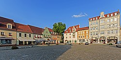
Sedlitz (Senftenberg)
| Senftenberg | ||
|---|---|---|

Market Square
|
||
|
||
| Coordinates: 51°31′N 14°01′E / 51.517°N 14.017°ECoordinates: 51°31′N 14°01′E / 51.517°N 14.017°E | ||
| Country | Germany | |
| State | Brandenburg | |
| District | Oberspreewald-Lausitz | |
| Government | ||
| • Mayor | Andreas Fredrich (SPD) | |
| Area | ||
| • Total | 127.56 km2 (49.25 sq mi) | |
| Elevation | 102 m (335 ft) | |
| Population (2015-12-31) | ||
| • Total | 24,625 | |
| • Density | 190/km2 (500/sq mi) | |
| Time zone | CET/CEST (UTC+1/+2) | |
| Postal codes | 01945 (Peickwitz), 01968 (Brieske, Großkoschen, Niemtsch, Sedlitz, Senftenberg), 01996 (Hosena) | |
| Dialling codes | 03573, 035756 (Hosena, Peickwitz) | |
| Vehicle registration | OSL, CA, SFB | |
| Website | www.senftenberg.de | |
Senftenberg (Sorbian: Zły Komorow) is a town in southern Brandenburg, Germany, capital of the Oberspreewald-Lausitz district. The river Schwarze Elster runs through Senftenberg and the town is located on the shores of Senftenberger See (Senftenberg Lake), one of the largest artificial lakes in Germany.
Senftenberg is located in the southwest of the historic Lower Lusatia region at the border with Saxony. Its town centre is situated north of the river Black Elster and the artificial Senftenberger Lake, part of the Lusatian Lake District chain, approximately 20 kilometres (12 mi) northwest of Hoyerswerda, and 35 kilometres (22 mi) southwest of Cottbus.
Senftenberg station is north of the centre and a major railway freight yard is located to its north-east, with a locomotive depot.
![]() Kingdom of Bohemia 1368-1448
Kingdom of Bohemia 1368-1448![]() Electorate of Saxony 1448-1806
Electorate of Saxony 1448-1806![]() Kingdom of Saxony 1806-1815
Kingdom of Saxony 1806-1815![]() Kingdom of Prussia 1815-1871
Kingdom of Prussia 1815-1871![]() German Empire 1871-1918
German Empire 1871-1918![]() Weimar Republic 1918-1933
Weimar Republic 1918-1933![]() Nazi Germany 1933-1945
Nazi Germany 1933-1945![]() Allied-occupied Germany 1945-1949
Allied-occupied Germany 1945-1949![]() East Germany 1949–1990
East Germany 1949–1990
...
Wikipedia


