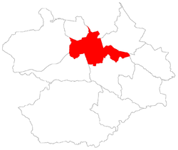
Sede, district of Santa Maria
|
District of Sede Sede, the 1st district of Santa Maria |
|
|---|---|
| District | |
 District of Sede, in Santa Maria City, Rio Grande do Sul, Brazil |
|
| Coordinates: 29°41′51.93″S 53°47′15.61″W / 29.6977583°S 53.7876694°WCoordinates: 29°41′51.93″S 53°47′15.61″W / 29.6977583°S 53.7876694°W | |
| Country | Brasil |
| State | Rio Grande do Sul |
| Municipality/City | Santa Maria |
| Government | |
| • Type | Subprefecture |
| • Body | Subprefect |
| Area | |
| • District | 133.71 km2 (51.63 sq mi) |
| Highest elevation | 300 m (984 ft) |
| Lowest elevation | 60 m (197 ft) |
| Population | |
| • District | 246,465 |
| • Rank | 1st of 10 |
| • Density | 1,800/km2 (4,800/sq mi) |
| • Urban | 246,465 |
| • Rural | 0 |
| Neighbourhoods | 41 |
| Adjacent districts | Arroio Grande, Boca do Monte, Pains, Palma, Santo Antão, São Valentim |
| Website | Official site of Santa Maria |
Sede ("Seat") is a district of the municipality of Santa Maria, in the Brazilian state of Rio Grande do Sul. It is situated in the north portion of Santa Maria. Downtown Santa Maria is one of its bairros (neighbourhoods).
The district of Sede owns an area of 133.71 km² that is equivalent to 7.46% of the municipality of Santa Maria that is 1791,65 km².
The district was created with the denomination of Santa Maria da Boca do Monte ("Saint Mary of mouth hill"), by provincial law number 6 of 1837, November 17, thus, the district still belonged to the municipality of Cachoeira do Sul. After, as Seat of the municipality of Santa Maria, the district gave origin, for separation, to many another districts, and, some of them became municipalities like Itaara.
The district of Sede contains the Downtown Santa Maria.
In 1982, the district had its first official division in bairros, in 1986 are made small changes. However, it was created detached bairros before 1982, like is the case of Bairro Roberto Holtermann that was created in 1961, and nowadays is part of the Nossa Senhora de Fátima neighbourhood with the name of Vila Holtermann.
...
Wikipedia
