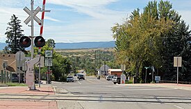
Sedalia, Colorado
| Sedalia, Colorado | |
|---|---|
| Census-designated place | |

Looking South on Manhart Street in Sedalia
|
|
 Location in Douglas County and the state of Colorado |
|
| Coordinates: 39°26′16″N 104°57′51″W / 39.43778°N 104.96417°WCoordinates: 39°26′16″N 104°57′51″W / 39.43778°N 104.96417°W | |
| Country |
|
| State |
|
| County | Douglas County |
| Area | |
| • Total | 1.4 sq mi (3.5 km2) |
| • Land | 1.4 sq mi (3.5 km2) |
| • Water | 0 sq mi (0 km2) |
| Elevation | 5,840 ft (1,780 m) |
| Population (2010) | |
| • Total | 206 |
| • Density | 151/sq mi (58.3/km2) |
| Time zone | MST (UTC-7) |
| • Summer (DST) | MDT (UTC-6) |
| ZIP code | 80135 |
| Area code(s) | Both 303 and 720 |
| FIPS code | 08-68875 |
| GNIS feature ID | 0204740 |
Sedalia is an unincorporated community and census-designated place (CDP) in Douglas County, Colorado, United States. The CDP population was 206 at the 2010 census. The Sedalia Post Office has the ZIP code 80135.
A post office called Sedalia has been in operation since 1872. The community was named after Sedalia, Missouri.
Sedalia is located in northwestern Douglas County at 39°26′16″N 104°57′51″W / 39.43778°N 104.96417°W (39.437892, −104.964117), along U.S. Route 85, which leads 8 miles (13 km) southeast to Castle Rock, the county seat, and north 24 miles (39 km) to downtown Denver.
According to the United States Census Bureau, the Sedalia CDP has a total area of 1.4 square miles (3.5 km2), all of it land. Sedalia is in the valley of Plum Creek, a north-flowing tributary of the South Platte River.
As of the census of 2000, there were 211 people, 94 households, and 54 families residing in the CDP. The population density was 152.2 people per square mile (58.6/km²). There were 99 housing units at an average density of 71.4 per square mile (27.5/km²). The racial makeup of the CDP was 93.84% White, 4.27% Asian, 1.90% from other races. Hispanic or Latino of any race were 4.27% of the population.
...
Wikipedia
