Sechelt
| Sechelt | |
|---|---|
| District municipality | |
| District of Sechelt | |
| Motto: Blessed by Sun and Seas | |
 |
|
| Coordinates: 49°28′27″N 123°45′15″W / 49.47417°N 123.75417°W | |
| Country |
|
| Province |
|
| Region | Sunshine Coast |
| Regional District | Sunshine Coast RD |
| Founded | 1862 (Roman Catholic mission) |
| Incorporated | Feb. 15, 1956 |
| Government | |
| • Mayor | Bruce Milne |
| • Governing body | Sechelt Municipal Council |
| • MLAs | Nicholas Simons, NDP |
| Area | |
| • District municipality | 39.71 km2 (15.33 sq mi) |
| Elevation | 8 m (26 ft) |
| Population (2006) | |
| • District municipality | 8,454 |
| • Density | 212.9/km2 (551/sq mi) |
| • Metro | 27,759 (regional district) |
| Time zone | PST (UTC-8) |
| Postal code span | V0N 3A0 |
| Area code(s) | +1-604 |
| Website | district.sechelt.bc.ca |
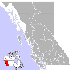
Coordinates: 49°28′27″N 123°45′15″W / 49.47417°N 123.75417°W The District Municipality of Sechelt /ˈsiːʃɛlt/ is located on the lower Sunshine Coast of British Columbia. Approximately 50 km northwest of Vancouver, it is accessible from mainland British Columbia by a 40-minute ferry trip between Horseshoe Bay and Langdale, and a 25-minute drive from Langdale along Highway 101, also known as the Sunshine Coast Highway. The name Sechelt means "land between two waters" in the language of the Coast Salish Shishalh people, who first settled the area thousands of years ago.
The original Village of Sechelt was incorporated on February 15, 1956. Sechelt later expanded its boundaries in 1986 with the inclusion of a number of adjacent unincorporated areas. The District of Sechelt, as it is known today, encompasses some 39.71 km² (15.33 sq mi) at the isthmus of the Sechelt Peninsula, between the southern tip of Sechelt Inlet (Porpoise Bay) and the Strait of Georgia that separates the provincial mainland from Vancouver Island.
...
Wikipedia
