Seatallan
| Seatallan | |
|---|---|

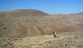
Seatallan seen from the neighbouring Middle Fell
|
|
| Highest point | |
| Elevation | 692 m (2,270 ft) |
| Prominence | 193 m (633 ft) |
| Parent peak | Pillar |
| Listing | Marilyn, Hewitt, Wainwright, Nuttall |
| Coordinates | 54°27′49″N 3°19′47″W / 54.46365°N 3.32982°WCoordinates: 54°27′49″N 3°19′47″W / 54.46365°N 3.32982°W |
| Geography | |
| Location | Cumbria, England |
| Parent range | Lake District, Western Fells |
| OS grid | NY139084 |
| Topo map | OS Landranger 89, Explorer OL6 |
Seatallan is a mountain in the western part of the English Lake District. It is rounded, grassy and fairly unassuming, occupying a large amount of land. However, it is classed as a Marilyn because of the low elevation of the col connecting it to Haycock, its nearest higher neighbour to the north. The name Seatallan is believed to have a Cumbric origin, meaning "Aleyn's high pasture".
The Western Fells occupy a triangular sector of the Lake District, bordered by the River Cocker to the north east and Wasdale to the south east. Westwards the hills diminish toward the coastal plain of Cumberland. At the central hub of the high country are Great Gable and its satellites, while two principal ridges fan out on either flank of Ennerdale, the western fells in effect being a great horseshoe around this long wild valley. Seatallan is an outlier of the southern arm.
The main watershed runs broadly westwards from Great Gable, dividing the headwaters of Ennerdale and Wasdale. Travelling in this direction the principal hills are Kirk Fell, Pillar, Scoat Fell, Haycock and Caw Fell. Haycock sends out a long southern ridge terminating in Seatallan.
Seatallan begins at the Pots of Ashness, a broad grassy depression to the south of Haycock. From here a stiff ascent up what may have been a landslip leads directly to the summit. The top of the fell resembles a truncated cone, cut off at an angle and sloping away to the south. This cone in turn stands upon a much broader upland plateau which stretches away five miles to the south west. The River Bleng forms the entire western boundary, beginning on the slopes of Haycock and then flowing out in a huge loop to the south west. It finally joins the Irt and continues on to the sea at Ravenglass. The extremity of the Bleng's circuit, near to Gosforth, is given over to lowland cultivation and although belonging topographically to Seatallan could hardly be termed fellside. Higher up the south western shoulder are conifer plantations, both along the Bleng and above the Irt. Open fellside begins two miles south west of the summit.
...
Wikipedia

