Pillar (Lake District)
| Pillar | |
|---|---|

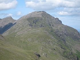
Pillar Rock is clearly visible on the skyline on the right. |
|
| Highest point | |
| Elevation | 892 m (2,927 ft) |
| Prominence | 348 m (1,142 ft) |
| Parent peak | Great Gable |
| Listing | Marilyn, Hewitt, Wainwright, Nuttall |
| Coordinates | 54°29′49″N 3°16′55″W / 54.497°N 3.282°WCoordinates: 54°29′49″N 3°16′55″W / 54.497°N 3.282°W |
| Geography | |
| Location | Cumbria, England |
| Parent range | Lake District, Western Fells |
| OS grid | NY171121 |
| Topo map | OS Landranger 89, Explorer OL4 |
| Listed summits of Pillar (Lake District) | ||||
| Name | Grid ref | Height | Status | |
|---|---|---|---|---|
| Pillar Rock | NY171123 | 780 m (2,558 ft) | Nuttall | |
| Looking Stead | NY186117 | 627 m (2,057 ft) | Nuttall | |
Pillar is a mountain in the western part of the English Lake District. Situated between the valleys of Ennerdale to the north and Wasdale to the south, it is the highest point of the Pillar group (some dozen fells clustered round it). At 892 metres (2,927 feet) it is the eighth-highest mountain in the Lake District. The fell takes its name from Pillar Rock, a prominent feature on the Ennerdale side, regarded as the birthplace of rock climbing in the district.
The Western Fells occupy a triangular sector of the Lake District, bordered by the River Cocker to the north east and Wasdale to the south east. Westwards the hills diminish toward the coastal plain of Cumberland. At the central hub of the high country are Great Gable and its satellites, while two principal ridges fan out on either flank of Ennerdale, the western fells in effect being a great horseshoe around this long wild valley. Pillar is on the southern arm.
The main watershed runs broadly westwards from Great Gable, dividing the headwaters of Ennerdale and Wasdale. The principal fells in this section are Kirk Fell, Pillar, Scoat Fell, Haycock and Caw Fell, followed by the lower Lank Rigg group.
Pillar stands on the southern wall of Ennerdale, three miles from the head of the valley. Two tiers of impressive crags run the full length of the fell from Wind Gap in the west to Black Sail Pass in the east. The top tier fronts the summit ridge, a series of coves being interspersed between the buttresses. Below is a narrow terrace bearing the 'High Level Route' path and then a further wall including Pillar Rock, Raven and Ash Crags and Proud Knott. The lower slopes are planted with a broad belt of conifers, extending across the River Liza to the flanks of High Crag.
...
Wikipedia

