Searcy County, Arkansas
| Searcy County, Arkansas | |
|---|---|

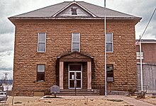
Searcy County Courthouse
|
|
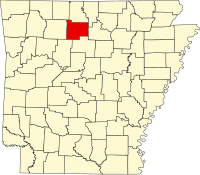
 Location in the U.S. state of Arkansas |
|
 Arkansas's location in the U.S. |
|
| Founded | December 13, 1838 |
| Seat | Marshall |
| Largest city | Marshall |
| Area | |
| • Total | 669 sq mi (1,733 km2) |
| • Land | 666 sq mi (1,725 km2) |
| • Water | 2.4 sq mi (6 km2), 0.4% |
| Population (est.) | |
| • (2015) | 7,869 |
| • Density | 12/sq mi (5/km²) |
| Congressional districts | 1st, 3rd |
| Time zone | Central: UTC-6/-5 |
Searcy County is a county located in the U.S. state of Arkansas. As of the 2010 census, the population was 8,195. The county seat is Marshall. The county was formed December 13, 1838, from a portion of Marion County and named for Richard Searcy, the first clerk and judge in the Arkansas Territory. The city of Searcy, Arkansas, some seventy miles away, shares the name despite having never been part of Searcy County. The county is an alcohol prohibition or dry county.
During the American Civil War, Searcy County, Arkansas had strong, pro-Union leanings, forming an organization, known as the "Arkansas Peace Society".[1]
According to the U.S. Census Bureau, the county has a total area of 669 square miles (1,730 km2), of which 666 square miles (1,720 km2) is land and 2.4 square miles (6.2 km2) (0.4%) is water.
As of the 2000 United States Census, there were 8,261 people, 3,523 households, and 2,466 families residing in the county. The population density was 12 people per square mile (5/km²). There were 4,292 housing units at an average density of 6 per square mile (2/km²). The racial makeup of the county was 97.26% White, 0.04% Black or African American, 0.75% Native American, 0.15% Asian, 0.01% Pacific Islander, 0.45% from other races, and 1.34% from two or more races. 1.04% of the population were Hispanic or Latino of any race.
...
Wikipedia
