Scottsville, Texas
| Scottsville, Texas | |
|---|---|
| City | |

|
|
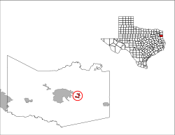
 Location of Scottsville in Harrison County, Texas. |
|
| Coordinates: 32°32′10″N 94°14′30″W / 32.53611°N 94.24167°WCoordinates: 32°32′10″N 94°14′30″W / 32.53611°N 94.24167°W | |
| Country | United States |
| State | Texas |
| County | Harrison |
| Area | |
| • Total | 1.3 sq mi (3.4 km2) |
| • Land | 1.3 sq mi (3.4 km2) |
| • Water | 0.0 sq mi (0.0 km2) |
| Elevation | 410 ft (125 m) |
| Population (2000) | |
| • Total | 263 |
| • Density | 200.5/sq mi (77.4/km2) |
| Time zone | Central (CST) (UTC-6) |
| • Summer (DST) | CDT (UTC-5) |
| ZIP code | 75688 |
| Area code(s) | 430, 903 |
| FIPS code | 48-66332 |
| GNIS feature ID | 1346827 |
Scottsville is a city in Harrison County, Texas, United States. The population was 263 at the 2000 census. A July 1, 2008 U.S. Census Bureau estimate placed the population at 272.
Scottsville is located at 32°32′10″N 94°14′30″W / 32.53611°N 94.24167°W (32.536098, -94.241611) along Farm Roads 1998 and 2199, north of U.S. Highway 80 in east central Harrison County. It is approximately four miles east of Marshall.
According to the United States Census Bureau, the city has a total area of 1.3 square miles (3.4 km2), all of it land.
The climate in this area is characterized by hot, humid summers and generally mild to cool winters. According to the Köppen Climate Classification system, Scottsville has a humid subtropical climate, abbreviated "Cfa" on climate maps.
The area was initially settled by William Thomas Scott, his wife Mary Rose, and other members of their families in June 1840. He quickly acquired several large parcels of land, established five cotton plantations, including Scottsville Plantation – his residence, constructed by slaves. Scott's lavish plantation was said to be identical to Jefferson Davis' mansion in Mississippi and he eventually became the largest slave owner in Harrison County.
...
Wikipedia
