Scollard Formation
| Scollard Formation Stratigraphic range: Maastrichtian to Danian |
|
|---|---|

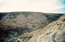
Scollard Formation exposed along the Red Deer River, Alberta. The Tyrannosaurus rex skeleton on display at the Royal Tyrrell Museum of Palaeontology was excavated in the center of image.
|
|
| Type | Geological formation |
| Unit of | Edmonton Group |
| Sub-units | Ardley coal zone |
| Underlies | Paskapoo Formation |
| Overlies | Battle Formation |
| Thickness | Up to 300 metres (980 ft) |
| Lithology | |
| Primary | Sandstone, siltstone, shale |
| Other | Coal, bentonite |
| Location | |
| Coordinates | 51°56′19″N 112°55′37″W / 51.93861°N 112.92694°WCoordinates: 51°56′19″N 112°55′37″W / 51.93861°N 112.92694°W |
| Region |
|
| Country |
|
| Type section | |
| Named for | Scollard Canyon at Dry Island Buffalo Jump Provincial Park |
| Named by | Irish, E.J.W |
The Scollard Formation is an Upper Cretaceous to lower Palaeocene stratigraphic unit of the Western Canada Sedimentary Basin in southwestern Alberta. Its deposition spanned the time interval from latest Cretaceous to early Paleocene, and it includes sediments that were deposited before, during, and after the Cretaceous-Paleogene (K-Pg) extinction event. It is significant for its fossil record, and it includes the economically important coal deposits of the Ardley coal zone.
The Scollard Formation consists primarily of sandstones and siltstones, interbedded with mudstones and, in the upper portion, coal seams, as well as minor amounts of bentonite. The sediments were eroded from the Canadian Cordillera, and were transported eastward by river systems and deposited in fluvial channel and floodplain environments.
The Scollard is usually classified as the uppermost formation of the Edmonton Group, although some early workers included it in the overlying Paskapoo Formation. It is subdivided into an upper, coal-bearing member that consists of the Ardley coal zone, and a lower member that lacks significant coal. Neither member has been formally named.
The K-Pg boundary occurs at the base of the lowermost seam of Ardley coal zone, based on dinosaurian and microfloral evidence, as well as the presence of the terminal Cretaceous iridium anomaly. The upper member is therefore of early Paleocene age, while the lower member is of latest Cretaceous age.
The Scollard Formation is present in the subsurface throughout much of southwestern Alberta, and it outcrops extensively along the banks of the Red Deer River in the area of Trochu. Both the upper and lower members thin from west to east. Thicknesses for each member range from more than 300 metres (980 ft) near the foothills of the Canadian Rockies to less than 100 metres (330 ft) near the outcrops in south-central Alberta.
...
Wikipedia
